IMAGES TAKEN NEAR TO
Potter Walk, CHELTENHAM, GL54 3BE
Introduction
This page details the photographs taken nearby to Potter Walk, GL54 3BE by members of the Geograph project.
The Geograph project started in 2005 with the aim of publishing, organising and preserving representative images for every square kilometre of Great Britain, Ireland and the Isle of Man.

There are currently over 7.5m images from over14,400 individuals and you can help contribute to the project by visiting https://www.geograph.org.uk
Image Map (Loading...)


Getting Data...Please wait
Leaflet Map data © OpenStreetMap
Images are licensed for reuse under creativecommons.org/licenses/by-sa/2.0
Notes
- Clicking on the map will re-center to the selected point.
- The higher the marker number, the further away the image location is from the centre of the postcode.
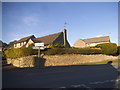
Image Listing (5 Images Found)
Images are licensed for reuse under creativecommons.org/licenses/by-sa/2.0
Image
Details
Distance
1
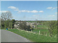
Valley of the River Leach east of Northleach
Image: © Stuart Logan
Taken: 13 Apr 2014
0.11 miles
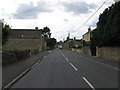
3
Eastington Road at the junction of East End
Image: © David Howard
Taken: 17 Sep 2017
0.11 miles
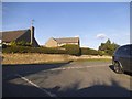
5
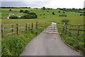
Access to sewage treatment plant
Access to sewage treatment plant in the Leach valley to the east of Northleach.
Image: © Philip Halling
Taken: 23 Jun 2012
0.23 miles