IMAGES TAKEN NEAR TO
Varsity Close, CHELTENHAM, GL54 2QE
Introduction
This page details the photographs taken nearby to Varsity Close, GL54 2QE by members of the Geograph project.
The Geograph project started in 2005 with the aim of publishing, organising and preserving representative images for every square kilometre of Great Britain, Ireland and the Isle of Man.

There are currently over 7.5m images from over14,400 individuals and you can help contribute to the project by visiting https://www.geograph.org.uk
Image Map
Images are licensed for reuse under creativecommons.org/licenses/by-sa/2.0
Notes
- Clicking on the map will re-center to the selected point.
- The higher the marker number, the further away the image location is from the centre of the postcode.
Image Listing (16 Images Found)
Images are licensed for reuse under creativecommons.org/licenses/by-sa/2.0
Image
Details
Distance
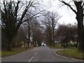
2
![Upper Rissington Business Park [3]](https://s0.geograph.org.uk/geophotos/02/73/23/2732348_1332814f_120x120.jpg)
Upper Rissington Business Park [3]
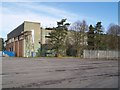
Much of the former RAF Little Rissington has become a business park. This view is of the main entrance to the park along Randall Road. The airfield was built in 1937 and soon came to dominate the village and the surrounding area with the residential quarters belonging to it housing nine-tenths of the population of the parish. For many years it was the home of the Central Flying School and is now an active Flying Training aerodrome under No.22 (Training) Group. A fascinating history is at http://www.centralflyingschool.org.uk/History/History3.htm There is a RAF Memorial Window in Little Rissington church and part of the graveyard was reserved for those killed whilst on duty at RAF Little Rissington.
Image: © Michael Dibb
Taken: 4 Sep 2011
0.07 miles
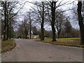
5
![Upper Rissington Business Park [1]](https://s0.geograph.org.uk/geophotos/02/73/23/2732332_62ea1d41_120x120.jpg)
Upper Rissington Business Park [1]
Much of the former RAF Little Rissington has become a business park. This view is along A P Ellis Road. The airfield was built in 1937 and soon came to dominate the village and the surrounding area with the residential quarters belonging to it housing nine-tenths of the population of the parish. For many years it was the home of the Central Flying School and is now an active Flying Training aerodrome under No.22 (Training) Group. A fascinating history is at http://www.centralflyingschool.org.uk/History/History3.htm There is a RAF Memorial Window in Little Rissington church and part of the graveyard was reserved for those killed whilst on duty at RAF Little Rissington.
Image: © Michael Dibb
Taken: 4 Sep 2011
0.10 miles
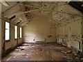
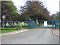
9
![Upper Rissington Business Park [2]](https://s0.geograph.org.uk/geophotos/02/73/23/2732340_ffb0819e_120x120.jpg)
Upper Rissington Business Park [2]
Much of the former RAF Little Rissington has become a business park. This view is of the gates at the entrance to A P Ellis Road. The airfield was built in 1937 and soon came to dominate the village and the surrounding area with the residential quarters belonging to it housing nine-tenths of the population of the parish. For many years it was the home of the Central Flying School and is now an active Flying Training aerodrome under No.22 (Training) Group. A fascinating history is at http://www.centralflyingschool.org.uk/History/History3.htm There is a RAF Memorial Window in Little Rissington church and part of the graveyard was reserved for those killed whilst on duty at RAF Little Rissington.
Image: © Michael Dibb
Taken: 4 Sep 2011
0.13 miles
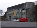
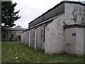
10
Upper Rissington Business Park
The gates to the business park in what was once part of the RAF base.
Image: © David Stowell
Taken: 3 Sep 2006
0.14 miles