IMAGES TAKEN NEAR TO
Whiteshoots Hill, CHELTENHAM, GL54 2LE
Introduction
This page details the photographs taken nearby to Whiteshoots Hill, GL54 2LE by members of the Geograph project.
The Geograph project started in 2005 with the aim of publishing, organising and preserving representative images for every square kilometre of Great Britain, Ireland and the Isle of Man.

There are currently over 7.5m images from over14,400 individuals and you can help contribute to the project by visiting https://www.geograph.org.uk
Image Map (Loading...)


Getting Data...Please wait
Leaflet Map data © OpenStreetMap
Images are licensed for reuse under creativecommons.org/licenses/by-sa/2.0
Notes
- Clicking on the map will re-center to the selected point.
- The higher the marker number, the further away the image location is from the centre of the postcode.
Image Listing (30 Images Found)
Images are licensed for reuse under creativecommons.org/licenses/by-sa/2.0
Image
Details
Distance
2
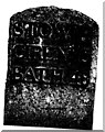
Old Milestone by the A429, Foss Way, Cold Aston parish
Metal plate attached to stone post by the A429, in parish of COLD ASTON (COTSWOLD District), 350m South of the A436 junction near Bourton stone, by the road, on Northwest side of road. Stow iron plate, erected by the Foss & Cross (Stow on the Wold) turnpike trust in the 19th century.
Inscription reads:-
STOW. 4
CIREN,R 15
BATH. 48
Carved benchmark on lower front.
Grade II listed.
List Entry Number: 1089869 https://historicengland.org.uk/listing/the-list/list-entry/1089869
Milestone Society National ID: GL_CISW15.
Image: © JM Weightmann
Taken: 1 Oct 2000
0.08 miles
3
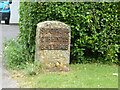
Milestone, A429
Whiteshoots Hill, Fosse Way. Near Bourton on the Water, NW side of the road. Cut BM representing 150.3 m ASL. Stow iron plate, erected by the Foss & Cross (Stow on the Wold) turnpike trust in the 19th century.
Inscription: Stow. 4 / Cirenᴿ. 15 / Bath 48
Grade II listed http://historicengland.org.uk/listing/the-list/list-entry/1089869
Milestone Society National ID: GL_CISW15
Image: © Sheila Allen
Taken: 11 Jun 2021
0.09 miles
4
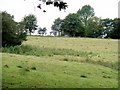
Gloucestershire pasture
The roof of a building peeks over the edge of the hill above the pasture. Seen from the footpath.
Image: © Michael Dibb
Taken: 30 Jul 2010
0.10 miles
5
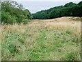
Rough ground
As the footpath nears Bourton-on-the-Water, it passes through this uncultivated area. The trees to the right mark the line of the A436 road.
Image: © Michael Dibb
Taken: 30 Jul 2010
0.15 miles
6
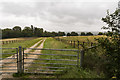
Gate and Farm Track
Just off the A429 on a wet day.
Image: © Julian P Guffogg
Taken: 16 Aug 2019
0.16 miles
7
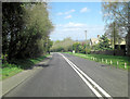
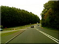
Junction of the A436 and the A429
This is where the two roads join just south of Bourton on the Water just before the Fosse Way crosses Bourton Bridge over the River Windrush.
Image: © Nigel Mykura
Taken: 4 Apr 2011
0.16 miles
9
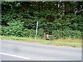
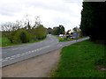
Footpath meets road
The footpath ends here where it meets the Old Gloucester Road (A436).
Image: © Michael Dibb
Taken: 30 Jul 2010
0.17 miles
10
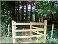
Through the plantation
The footpath passes through this gate through the four rows of trees that make up the plantation to reach its end at the Old Gloucester Road (A436).
Image: © Michael Dibb
Taken: 30 Jul 2010
0.17 miles