IMAGES TAKEN NEAR TO
Upper Slaughter, CHELTENHAM, GL54 2JT
Introduction
This page details the photographs taken nearby to GL54 2JT by members of the Geograph project.
The Geograph project started in 2005 with the aim of publishing, organising and preserving representative images for every square kilometre of Great Britain, Ireland and the Isle of Man.

There are currently over 7.5m images from over14,400 individuals and you can help contribute to the project by visiting https://www.geograph.org.uk
Image Map (Loading...)


Getting Data...Please wait
Leaflet Map data © OpenStreetMap
Images are licensed for reuse under creativecommons.org/licenses/by-sa/2.0
Notes
- Clicking on the map will re-center to the selected point.
- The higher the marker number, the further away the image location is from the centre of the postcode.
Image Listing (13 Images Found)
Images are licensed for reuse under creativecommons.org/licenses/by-sa/2.0
Image
Details
Distance
1
The Gashouses
Next to the old gasworks
Image: © Philip Jeffrey
Taken: 30 Aug 2021
0.01 miles
3
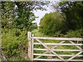
This is not the footpath
The main footpath between Stow-on-the-Wold and Lower Slaughter runs across the front of the photo. This inviting gate heads away from the crowds into another field but is not a right of way.
Image: © Graham Horn
Taken: 29 Apr 2007
0.09 miles
4
![Four Paths [3]](https://s0.geograph.org.uk/geophotos/01/62/37/1623772_6302999a_120x120.jpg)
Four Paths [3]
The footpath, part of four long distance paths, crosses the corner of this very muddy field on its way from Lower Slaughter to Hyde Mill.
Image: © Michael Dibb
Taken: 13 Dec 2009
0.13 miles
5
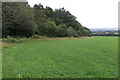
A stand of trees in a field
Flat farmland near Lower Slaughter.
Image: © Bill Boaden
Taken: 20 Oct 2017
0.15 miles
6
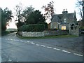
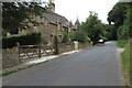
Road junction by Copse Hill Lodge
Image: © Jennifer Luther Thomas
Taken: 18 Nov 2006
0.17 miles
7
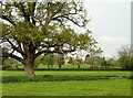
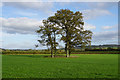
Towards Kirkham Farm
Kirkham Farm on the horizon is in the next square. A minor road runs across the middle of the scene in the square. This oak dominates the area, which is flat pasture land in the River Dikler floodplain, but very dry at present due to the dry spring.
Image: © Graham Horn
Taken: 29 Apr 2007
0.19 miles
8
![Four Paths [2]](https://s0.geograph.org.uk/geophotos/01/62/37/1623768_bce0be0c_120x120.jpg)
Four Paths [2]
Having crossed the hedge line, the footpath, part of four long distance paths, follows the field edge on its way from Lower Slaughter to Hyde Mill.
Image: © Michael Dibb
Taken: 13 Dec 2009
0.21 miles
9
![Four paths [4]](https://s1.geograph.org.uk/geophotos/01/62/37/1623773_a58714b4_120x120.jpg)
Four paths [4]
The footpath, part of four long distance paths, goes diagonally across this field on its way from Lower Slaughter to Hyde Mill. On this day, the entire field had been enclosed with an electric fence with no gaps or crossing points to accommodate walkers. The buildings of Kirkham Farm are visible in the background.
Image: © Michael Dibb
Taken: 13 Dec 2009
0.22 miles
