IMAGES TAKEN NEAR TO
Upper Slaughter, CHELTENHAM, GL54 2JS
Introduction
This page details the photographs taken nearby to GL54 2JS by members of the Geograph project.
The Geograph project started in 2005 with the aim of publishing, organising and preserving representative images for every square kilometre of Great Britain, Ireland and the Isle of Man.

There are currently over 7.5m images from over14,400 individuals and you can help contribute to the project by visiting https://www.geograph.org.uk
Image Map (Loading...)


Getting Data...Please wait
Leaflet Map data © OpenStreetMap
Images are licensed for reuse under creativecommons.org/licenses/by-sa/2.0
Notes
- Clicking on the map will re-center to the selected point.
- The higher the marker number, the further away the image location is from the centre of the postcode.
Image Listing (14 Images Found)
Images are licensed for reuse under creativecommons.org/licenses/by-sa/2.0
Image
Details
Distance
1
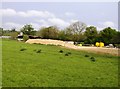
Farm buildings at Kirkham Farm
The livestock farm has a large complex of buildings away from the original farmhouse site.
Image: © Bill Boaden
Taken: 20 Oct 2017
0.10 miles
2
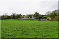
Farm storage area
View of the working side of a farm from the Macmillan Way, which crosses the adjacent grassland.
Image: © Graham Horn
Taken: 29 Apr 2007
0.12 miles
3
Cattle near Kirkham Farm
The footpath turns to the right, so you don't have to enter the farmyard.
Image: © Bill Boaden
Taken: 20 Oct 2017
0.16 miles
4
![Four paths [5]](https://s3.geograph.org.uk/geophotos/01/62/37/1623779_f062c2f3_120x120.jpg)
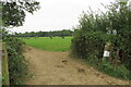
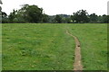
Four paths [5]
The footpath, part of four long distance paths, crosses this very long field on its way from Lower Slaughter to Hyde Mill.
Image: © Michael Dibb
Taken: 13 Dec 2009
0.16 miles
5
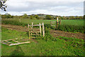
The Gloucestershire Way near Kirkham Farm
The path is heading towards Stow-on-the-Wold. It is crossing a farm track by means of two rickety but still effective gates.
Image: © Bill Boaden
Taken: 20 Oct 2017
0.17 miles
7
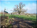
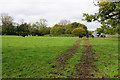
Path crossroads
This gateway is the meeting point for two paths. One path comes from behind the camera to the left and goes through the gate in the fence to the right. The second path comes from behind the camera to the right and goes straight on passing the farm buildings to the left. The four long distance paths all turn right here.
Image: © Michael Dibb
Taken: 13 Dec 2009
0.18 miles
8
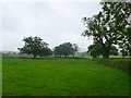
Valley of the River Dikler
Most of the fields in this vale are pastureland. Despite the unseasonable rain and mist the line of the river can just be seen in the far distance marked by a line of trees.
Image: © Nigel Mykura
Taken: 2 Jul 2012
0.18 miles