IMAGES TAKEN NEAR TO
Upper Slaughter, CHELTENHAM, GL54 2JL
Introduction
This page details the photographs taken nearby to GL54 2JL by members of the Geograph project.
The Geograph project started in 2005 with the aim of publishing, organising and preserving representative images for every square kilometre of Great Britain, Ireland and the Isle of Man.

There are currently over 7.5m images from over14,400 individuals and you can help contribute to the project by visiting https://www.geograph.org.uk
Image Map (Loading...)


Getting Data...Please wait
Leaflet Map data © OpenStreetMap
Images are licensed for reuse under creativecommons.org/licenses/by-sa/2.0
Notes
- Clicking on the map will re-center to the selected point.
- The higher the marker number, the further away the image location is from the centre of the postcode.
Image Listing (14 Images Found)
Images are licensed for reuse under creativecommons.org/licenses/by-sa/2.0
Image
Details
Distance
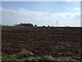
1
Eyford Knoll
A glimpse of the house and the farm from the B4068 road.farm
Image: © Michael Dibb
Taken: 7 Jun 2010
0.01 miles
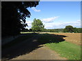
2
The Warden's Way
There are horses grazing in the field to the right. The valley on the left appears to be a dry one.
Image: © Bill Boaden
Taken: 8 Apr 2010
0.11 miles
3
![Amended sign [1]](https://s0.geograph.org.uk/geophotos/01/93/72/1937224_2168d946_120x120.jpg)
Amended sign [1]
This sign marks the road junction at the road to The Slaughters. It has been amended with patches to change the road number to the B4068. See Image
Image: © Michael Dibb
Taken: 7 Jun 2010
0.15 miles
4
![Amended sign [2]](https://s3.geograph.org.uk/geophotos/01/93/72/1937235_91abc058_120x120.jpg)
Amended sign [2]
This sign marks the road junction at the road to The Slaughters. On the front, it has been amended with patches to change the road number to the B4068. See Image The back seen here still shows the road number as A436.
Image: © Michael Dibb
Taken: 7 Jun 2010
0.15 miles
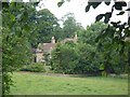
5
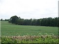
Privacy plantation
Seen from the minor road, across the field, is this plantation. The plantation is long but very narrow and its purpose seems to be to provide privacy for Eyford Knoll.
Image: © Michael Dibb
Taken: 7 Jun 2010
0.16 miles
6
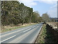
B4068 heading east
Towards Stow-on-the-Wold.
Image: © JThomas
Taken: 3 Apr 2013
0.18 miles
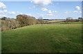
7
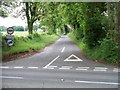
Road to The Slaughters
This road branches off the B4068 and heads to Upper Slaughter and Lower Slaughter.
Image: © Michael Dibb
Taken: 7 Jun 2010
0.18 miles
8
![Houses at Wales Barn [2]](https://s0.geograph.org.uk/geophotos/01/93/72/1937200_3cae9ef1_120x120.jpg)
Houses at Wales Barn [2]
Seen from the B4068 road.
Image: © Michael Dibb
Taken: 7 Jun 2010
0.22 miles