IMAGES TAKEN NEAR TO
The Square, CHELTENHAM, GL54 2JF
Introduction
This page details the photographs taken nearby to The Square, GL54 2JF by members of the Geograph project.
The Geograph project started in 2005 with the aim of publishing, organising and preserving representative images for every square kilometre of Great Britain, Ireland and the Isle of Man.

There are currently over 7.5m images from over14,400 individuals and you can help contribute to the project by visiting https://www.geograph.org.uk
Image Map (Loading...)


Getting Data...Please wait
Leaflet Map data © OpenStreetMap
Images are licensed for reuse under creativecommons.org/licenses/by-sa/2.0
Notes
- Clicking on the map will re-center to the selected point.
- The higher the marker number, the further away the image location is from the centre of the postcode.
Image Listing (95 Images Found)
Images are licensed for reuse under creativecommons.org/licenses/by-sa/2.0
Image
Details
Distance
1
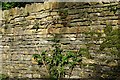
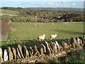
Cotswold stone wall
A beautiful constructed, well-kept cotswold drystone wall which was home to a variety of plant & animal life - sadly the animal life wouldn't stay still! Notice the size and shape of the stones in different layers of the wall. No mortar is used with the honey-coloured limestone and the craftsmen build the walls to let rainwater drain away quite naturally. The result is strong and enduring.
Image: © Natalia A McKenzie
Taken: 3 Jul 2008
0.01 miles
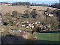
3
Upper Slaughter sheep pasture
This lane provides a good view of the village, which nestles in the valley below. The spire of Lower Slaughter Church can be seen further down the valley to the right.
Image: © Trevor Rickard
Taken: 21 Feb 2007
0.02 miles
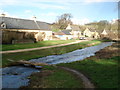
4
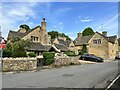
Cottages in the village centre
Upper Slaughter.
Image: © Andrew Abbott
Taken: 15 May 2022
0.02 miles
5

St Peter's Church, Upper Slaughter, Gloucestershire
The parish church of St Peter in Upper Slaughter.
Image: © Gary Brothwell
Taken: 20 Sep 2010
0.03 miles
6
Upper Slaughter village
Seen from the footpath leading to Manor Farm is this view across the village. The church of St Peter is on the extreme left. The trees lining the driveway to The Old Stables at Copse Hill are on the horizon left of centre.
Image: © Michael Dibb
Taken: 2 Jan 2010
0.04 miles
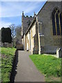
7
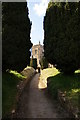
The path to St Peter's Church
Dominated by yew trees.
Image: © Bill Boaden
Taken: 8 Apr 2010
0.04 miles
8
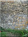
St Peter’s Church, Upper Slaughter, Benchmark
Image: © Cipollini
Taken: 6 Oct 2024
0.04 miles