IMAGES TAKEN NEAR TO
Beddome Way, CHELTENHAM, GL54 2GZ
Introduction
This page details the photographs taken nearby to Beddome Way, GL54 2GZ by members of the Geograph project.
The Geograph project started in 2005 with the aim of publishing, organising and preserving representative images for every square kilometre of Great Britain, Ireland and the Isle of Man.

There are currently over 7.5m images from over14,400 individuals and you can help contribute to the project by visiting https://www.geograph.org.uk
Image Map
Images are licensed for reuse under creativecommons.org/licenses/by-sa/2.0
Notes
- Clicking on the map will re-center to the selected point.
- The higher the marker number, the further away the image location is from the centre of the postcode.
Image Listing (25 Images Found)
Images are licensed for reuse under creativecommons.org/licenses/by-sa/2.0
Image
Details
Distance
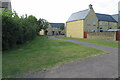
1
Cocooned bus shelter on Meadow Way
Or maybe it is an art installation
Image: © Philip Jeffrey
Taken: 5 Sep 2021
0.03 miles
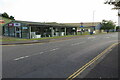
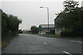
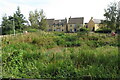
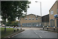
6
New housing development
On the edge of the Bourton Industrial Park.
Image: © andrew auger
Taken: 10 Apr 2009
0.11 miles
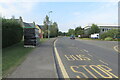
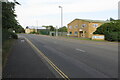
7
Speed hump on Bourton Industrial Estate
Image: © andrew auger
Taken: 9 Oct 2009
0.13 miles
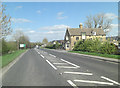
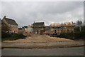
8
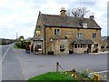
Coach and Horses
Built of Cotswold stone with a stone tile roof this old coaching inn is at the side of the A429 the Fosse Way
Image: © Nigel Mykura
Taken: 4 Apr 2011
0.13 miles