IMAGES TAKEN NEAR TO
Maugersbury, CHELTENHAM, GL54 1HR
Introduction
This page details the photographs taken nearby to GL54 1HR by members of the Geograph project.
The Geograph project started in 2005 with the aim of publishing, organising and preserving representative images for every square kilometre of Great Britain, Ireland and the Isle of Man.

There are currently over 7.5m images from over14,400 individuals and you can help contribute to the project by visiting https://www.geograph.org.uk
Image Map (Loading...)


Getting Data...Please wait
Leaflet Map data © OpenStreetMap
Images are licensed for reuse under creativecommons.org/licenses/by-sa/2.0
Notes
- Clicking on the map will re-center to the selected point.
- The higher the marker number, the further away the image location is from the centre of the postcode.
Image Listing (34 Images Found)
Images are licensed for reuse under creativecommons.org/licenses/by-sa/2.0
Image
Details
Distance
1
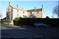
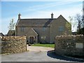
House in Maugersbury
Cotswold stone built house in Maugersbury.
Image: © Philip Halling
Taken: 6 Dec 2014
0.04 miles
2
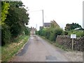
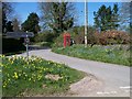
Private road?
On the OS map, this is shown as a public road, but perhaps not.
Image: © Michael Dibb
Taken: 7 Jul 2010
0.05 miles
3
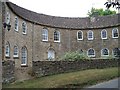
Half Moon House
This unusual house which commands extensive views is aptly named.
Image: © Michael Dibb
Taken: 7 Jul 2010
0.05 miles
4
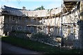
Half Moon House
Half Moon House in Maugersbury is currently under scaffolding. Formerly known as The Crescent this unusual building dates from around 1800 and was built by Edmund John Chamberlayne, as a philanthropic venture, being originally a Sunday School and four cottages. It is a Grade II listed building.
Image: © Philip Halling
Taken: 6 Dec 2014
0.05 miles
5
Chapel Street, Maugersbury
The street forms part of the Macmillan Way long distance footpath.
Image: © Michael Dibb
Taken: 21 Apr 2010
0.05 miles
6
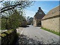
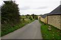
Road junction in Maugersbury
The quiet village is very close to Stow-on-the-Wold but off the beaten track.
Image: © Bill Boaden
Taken: 20 Oct 2017
0.05 miles
7
Newly built
This newly built house in Maugersbury has not yet had its name inscribed on the wall.
Image: © Michael Dibb
Taken: 21 Apr 2010
0.06 miles
8
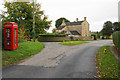
Road junction with forget-me-nots
In Maugersbury village.
Image: © Michael Dibb
Taken: 21 Apr 2010
0.06 miles
9
Stone at Maugersbury
What appears to be a standing stone in the village of Maugersbury.
Image: © Philip Halling
Taken: 6 Dec 2014
0.09 miles
10
Lane passing Tythe Farm
The eastern end of the village of Maugersbury.
Image: © Bill Boaden
Taken: 20 Oct 2017
0.10 miles