IMAGES TAKEN NEAR TO
Newlands Court, CHELTENHAM, GL54 1HN
Introduction
This page details the photographs taken nearby to Newlands Court, GL54 1HN by members of the Geograph project.
The Geograph project started in 2005 with the aim of publishing, organising and preserving representative images for every square kilometre of Great Britain, Ireland and the Isle of Man.

There are currently over 7.5m images from over14,400 individuals and you can help contribute to the project by visiting https://www.geograph.org.uk
Image Map (90 Images)


Getting Data...Please wait
Leaflet Map data © OpenStreetMap
Images are licensed for reuse under creativecommons.org/licenses/by-sa/2.0
Notes
- Clicking on the map will re-center to the selected point.
- The higher the marker number, the further away the image location is from the centre of the postcode.
Image Listing (90 Images Found)
Images are licensed for reuse under creativecommons.org/licenses/by-sa/2.0
Image
Details
Distance
1
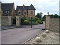
Newlands Court
These recently built properties are in the triangle of land between Evesham Road (A424) and Tewkesbury Road (B4077) in Stow-on-the-Wold.
Image: © Michael Dibb
Taken: 15 Jun 2010
0.02 miles
2
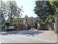
Newlands of Stow
Care home on the Evesham Road in Stow
Image: © Eirian Evans
Taken: 26 Aug 2019
0.02 miles
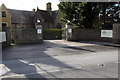
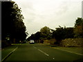
6
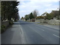
Approaching Stow-on-the-Wold
The A424, Evesham Road, approaching the junctions with the B4077 and the Fosse Way A429.
Image: © Michael Dibb
Taken: 15 Jun 2010
0.04 miles
7
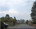
Evesham Road (A424) north of Stow-on-The-Wold
Advance sign for the junction with A429
Image: © David Smith
Taken: 7 May 2016
0.05 miles
8
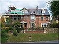
The Limes
This attractive Victorian villa is now The Limes, a bed and breakfast establishment.
Image: © Michael Dibb
Taken: 15 Jun 2010
0.06 miles
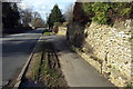
10
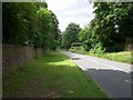
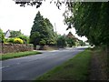
The road to Upper Swell
The B4077 roads descends steeply towards Upper Swell. The road forms part of the Gloucestershire Way long distance path and the wide verge acts as a footpath.
Image: © Michael Dibb
Taken: 15 Jun 2010
0.09 miles