IMAGES TAKEN NEAR TO
Kingscourt Lane, STROUD, GL5 3QP
Introduction
This page details the photographs taken nearby to Kingscourt Lane, GL5 3QP by members of the Geograph project.
The Geograph project started in 2005 with the aim of publishing, organising and preserving representative images for every square kilometre of Great Britain, Ireland and the Isle of Man.

There are currently over 7.5m images from over14,400 individuals and you can help contribute to the project by visiting https://www.geograph.org.uk
Image Map
Images are licensed for reuse under creativecommons.org/licenses/by-sa/2.0
Notes
- Clicking on the map will re-center to the selected point.
- The higher the marker number, the further away the image location is from the centre of the postcode.
Image Listing (55 Images Found)
Images are licensed for reuse under creativecommons.org/licenses/by-sa/2.0
Image
Details
Distance
1
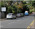
Kingscourt Lane, Stroud
Descending from Walkley Hill. No motor vehicles except for access.
Image: © Jaggery
Taken: 18 Oct 2015
0.03 miles
2
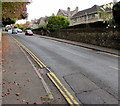
Court Way, Stroud
Descending from Walkley Hill. Rodborough Court http://www.geograph.org.uk/photo/4706440 is behind the camera.
Image: © Jaggery
Taken: 18 Oct 2015
0.06 miles
3
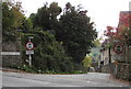
Walkley Hill direction sign, Rodborough, Stroud
The sign near the corner of Court Way is on the descent towards the A46 Bath Road crossroads.
Image: © Jaggery
Taken: 18 Oct 2015
0.07 miles
4
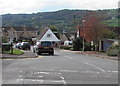
Up Walkley Hill, Rodborough, Stroud
Viewed opposite the Kingscourt Lane junction. http://www.geograph.org.uk/photo/4706424
Walkley Hill is part of the route from the A46 Bath Road to Minchinhampton, about 5km ahead.
Image: © Jaggery
Taken: 18 Oct 2015
0.08 miles
5
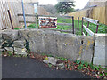
Stone Stile, Rodborough
On Walkley Hill South side, leading to Stringers Farm. This is looking in, the view looking North is Image
Image: © Mr Red
Taken: 10 Dec 2021
0.08 miles
6
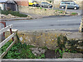
Stone Stile, Rodborough
On Walkley Hill South side, leading to Stringers Farm. This is looking out, the view looking South is Image
Image: © Mr Red
Taken: 10 Dec 2021
0.08 miles
7
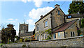
Rose Cottage, Rodborough
One of the several cottages that surround the church at Rodborough.
Image: © Philip Pankhurst
Taken: 15 May 2014
0.08 miles
8
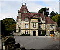
Rodborough Court, Stroud
Set back from the north side of Walkley Hill, Rodborough Court was built in 1888 for the Apperly family.
Grade II listed in 1974.
Image: © Jaggery
Taken: 18 Oct 2015
0.08 miles
9
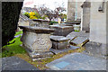
Tumbling table tombs, Rodborough
A profusion of monuments by the South porch at Rodborough.
Image: © Philip Pankhurst
Taken: 15 May 2014
0.09 miles
10
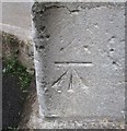
Ordnance Survey Cut Mark
This OS cut mark can be found on the SW face of the Church. It marks a point 100.5109m above mean sea level.
Image: © Adrian Dust
Taken: 13 Sep 2016
0.09 miles