IMAGES TAKEN NEAR TO
Cromwell Terrace, Dudbridge Road, STROUD, GL5 3HH
Introduction
This page details the photographs taken nearby to Cromwell Terrace, Dudbridge Road, GL5 3HH by members of the Geograph project.
The Geograph project started in 2005 with the aim of publishing, organising and preserving representative images for every square kilometre of Great Britain, Ireland and the Isle of Man.

There are currently over 7.5m images from over14,400 individuals and you can help contribute to the project by visiting https://www.geograph.org.uk
Image Map (Loading...)


Getting Data...Please wait
Leaflet Map data © OpenStreetMap
Images are licensed for reuse under creativecommons.org/licenses/by-sa/2.0
Notes
- Clicking on the map will re-center to the selected point.
- The higher the marker number, the further away the image location is from the centre of the postcode.
Image Listing (58 Images Found)
Images are licensed for reuse under creativecommons.org/licenses/by-sa/2.0
Image
Details
Distance
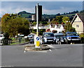
1

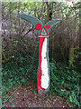
Milestone, Dubridge Road, Dudbridge, Stroud
Leaning to the South West, the road is slightly uphill at this point. The factory to the left is a re-cycling processing plant. Other milestones in the area see http://umap.openstreetmap.fr/en/map/stonehouse-milestones_519080#12
Inscription (was): Gloucester 11 / Bath 26
Milestone Society National ID: GL_BAGL28
Image: © Mr Red
Taken: 7 Nov 2020
0.04 miles
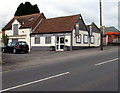
3

Dudbridge Cycle Track
The railway line ran between Dudbridge and Stroud and is viewed from the Dudbridge End. Nowadays it's the best made bit of cycle track in Stroud, it's a pity the access is by a flight of stairs. The road bridge carries traffic between Dudbridge Hill and Dudbridge.
Image: © Peter Kwan
Taken: 31 Dec 2002
0.10 miles
4
National Cycle Network signpost, Dudbridge
On the old Midland Rail line where the original line crossed Dudbridge Road at the site of the bridge abutment. Route 45. The cycle route below this fingerpost is steps! But there is a groove for cycle wheels.
Millennium Time Trail ID: MP689 see http://umap.openstreetmap.fr/en/map/sustrans-mileposts_71773#15/51.7384/-2.2348
Image: © Mr Red
Taken: 17 Sep 2020
0.10 miles
5

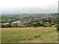
Rodborough
A mix of industrial and residential housing in Rodborough, viewed from Rodborough Common.
Image: © Philip Halling
Taken: 11 Oct 2014
0.10 miles
6

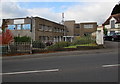
Springfield Engineering (Stroud) Ltd
Located in Daniels Industrial Estate, viewed across the A46 Bath Road.
Image: © Jaggery
Taken: 18 Oct 2015
0.13 miles
7
Fern House, Daniels Industrial Estate near Stroud
Premises of Meningitis Now. Its website states
"Our vision is a future where no-one in the UK loses their life to meningitis
and everyone affected gets the support they need to rebuild their lives."
Image: © Jaggery
Taken: 18 Oct 2015
0.15 miles
8
Over Stroud to Doverow Hill - Gloucestershire
Looking out across Stroud from Rodborough Common towards Doverow Hill and the Severn. This shows the expansion of Stroud from what was once a hamlet, a chapelry of nearby Bisley, to its present status as a town and centre of communications in its own right. Time taken 5.59 pm BST (British Summer Time).
Image: © Martin Richard Phelan
Taken: 16 Aug 2008
0.15 miles
9
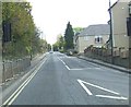
Top of Dudbridge Hill, Rodborough, Stroud
Dudbridge Hill descends towards Dudbridge from the A46 Bath Road.
Image: © Jaggery
Taken: 18 Oct 2015
0.16 miles
10
Hybrid Windows showroom, Stroud
Part of Daniels Industrial Estate, viewed across the A46 Bath Road.
Image: © Jaggery
Taken: 18 Oct 2015
0.16 miles