IMAGES TAKEN NEAR TO
Lodgemore Lane, STROUD, GL5 3EG
Introduction
This page details the photographs taken nearby to Lodgemore Lane, GL5 3EG by members of the Geograph project.
The Geograph project started in 2005 with the aim of publishing, organising and preserving representative images for every square kilometre of Great Britain, Ireland and the Isle of Man.

There are currently over 7.5m images from over14,400 individuals and you can help contribute to the project by visiting https://www.geograph.org.uk
Image Map
Images are licensed for reuse under creativecommons.org/licenses/by-sa/2.0
Notes
- Clicking on the map will re-center to the selected point.
- The higher the marker number, the further away the image location is from the centre of the postcode.
Image Listing (163 Images Found)
Images are licensed for reuse under creativecommons.org/licenses/by-sa/2.0
Image
Details
Distance
1
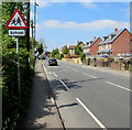
Warning sign - School, Cainscross Road, Stroud
Facing westbound traffic on the A419 Cainscross Road on the approach to Stroud High School.
Image: © Jaggery
Taken: 7 May 2017
0.01 miles
2
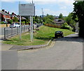
Lodgemore Lane, Stroud
Lodgemore Lane descends from Cainscross Road towards the Stroudwater Canal.
The WSP Textiles notice shows CAUTION - NARROW ROAD - NO CONTAINERS, NO TURNING.
Image: © Jaggery
Taken: 7 May 2017
0.02 miles
3
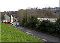
Lodgemore Lane, Stroud
Lodgemore Lane descends from Cainscross Road towards the Stroudwater Canal.
Image: © Jaggery
Taken: 17 Feb 2013
0.03 miles
4
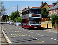
Double-decker bus, Cainscross Road, Stroud
Text on the side of the bus is "abus 1991-2016 Serving Bristol for over 25 years".
Abus is an independent bus company providing local bus services in Bristol, Bath and surrounding areas. Stroud doesn't quite match that area, and the electronic display on the front of the bus shows only the company's website address, from which I concluded that this bus is on special hire, not on a regular route.
Image: © Jaggery
Taken: 7 May 2017
0.03 miles
5
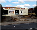
Carpet & Flooring shop in Stroud
Viewed across Cainscross Road.
Image: © Jaggery
Taken: 17 Feb 2013
0.04 miles
6
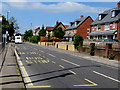
Three bus bays near Stroud High School, Stroud
The bays numbered 15,14,13 on Cainscross Road are used by school buses.
Image: © Jaggery
Taken: 7 May 2017
0.04 miles
7
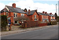
Cainscross Road houses, Stroud
On the north side of the road, between Lodgemore Lane and Gannicox Road.
Image: © Jaggery
Taken: 17 Feb 2013
0.05 miles
8
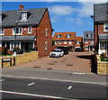
John Harper Close, Stroud
Recently built cul-de-sac on the north side of the A419 Cainscross Road viewed in May 2017.
Image: © Jaggery
Taken: 7 May 2017
0.06 miles
9
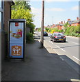
McDonald's advert on a BT phonebox, Cainscross Road, Stroud
Image: © Jaggery
Taken: 7 May 2017
0.06 miles
10

Cainscross Rd
This brick built apartment block is on Cainscross Rd opposite the junction with Gannicox Rd.
Image: © Nigel Mykura
Taken: 7 Oct 2011
0.07 miles