IMAGES TAKEN NEAR TO
Strachans Close, STROUD, GL5 3EB
Introduction
This page details the photographs taken nearby to Strachans Close, GL5 3EB by members of the Geograph project.
The Geograph project started in 2005 with the aim of publishing, organising and preserving representative images for every square kilometre of Great Britain, Ireland and the Isle of Man.

There are currently over 7.5m images from over14,400 individuals and you can help contribute to the project by visiting https://www.geograph.org.uk
Image Map (Loading...)


Getting Data...Please wait
Leaflet Map data © OpenStreetMap
Images are licensed for reuse under creativecommons.org/licenses/by-sa/2.0
Notes
- Clicking on the map will re-center to the selected point.
- The higher the marker number, the further away the image location is from the centre of the postcode.
Image Listing (141 Images Found)
Images are licensed for reuse under creativecommons.org/licenses/by-sa/2.0
Image
Details
Distance
1
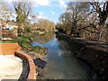
East along the Stroudwater Canal from Chestnut Lane bridge, Stroud
Viewed from this http://www.geograph.org.uk/photo/3827396 swingbridge.
Image: © Jaggery
Taken: 17 Feb 2013
0.03 miles
2
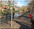
Public footpath along the Stroudwater Canal, Stroud
Chestnut Lane swingbridge http://www.geograph.org.uk/photo/3827396 is a few metres behind the camera.
Image: © Jaggery
Taken: 17 Feb 2013
0.03 miles
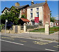
3
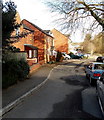
Strachans Close, Stroud
Viewed from the Chestnut Lane end. The houses are on the north side of Strachans Close, facing the Stroudwater Canal.
Image: © Jaggery
Taken: 17 Feb 2013
0.04 miles
4
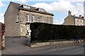
Probation Service office in Stroud
Located in The Firs, Cainscross Road.
Image: © Jaggery
Taken: 17 Feb 2013
0.04 miles
5
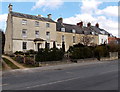
Cainscross Road houses, Stroud
Viewed looking towards the Beard's Lane junction.
Image: © Jaggery
Taken: 17 Feb 2013
0.04 miles
6

Queen Elizabeth II postbox on a Stroud corner
On the corner of the A419 Cainscross Road and Beard's Lane.
Image: © Jaggery
Taken: 7 May 2017
0.04 miles
7
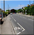
Cainscross Road cycle lane, Stroud
Broken white lines mark the cycle lane on the south side of the A419 Cainscross Road.
Image: © Jaggery
Taken: 7 May 2017
0.05 miles
8
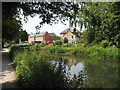
The Stroudwater Canal
Looking downstream, just west of Stroud.
Image: © David Purchase
Taken: 21 Jun 2017
0.05 miles
9
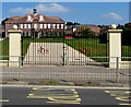
Stroud High School entrance gates, Stroud
On the north side of the A419 Cainscross Road.
Image: © Jaggery
Taken: 7 May 2017
0.05 miles
10
Stroud High School bus stop, Stroud
On the north side of A419 Cainscross Road. The school entrance gates http://www.geograph.org.uk/photo/5393879 are on the right.
Image: © Jaggery
Taken: 7 May 2017
0.06 miles