IMAGES TAKEN NEAR TO
Copt Elm Close, CHELTENHAM, GL53 8AF
Introduction
This page details the photographs taken nearby to Copt Elm Close, GL53 8AF by members of the Geograph project.
The Geograph project started in 2005 with the aim of publishing, organising and preserving representative images for every square kilometre of Great Britain, Ireland and the Isle of Man.

There are currently over 7.5m images from over14,400 individuals and you can help contribute to the project by visiting https://www.geograph.org.uk
Image Map (Loading...)


Getting Data...Please wait
Leaflet Map data © OpenStreetMap
Images are licensed for reuse under creativecommons.org/licenses/by-sa/2.0
Notes
- Clicking on the map will re-center to the selected point.
- The higher the marker number, the further away the image location is from the centre of the postcode.
Image Listing (103 Images Found)
Images are licensed for reuse under creativecommons.org/licenses/by-sa/2.0
Image
Details
Distance
1
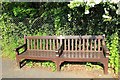
Stuart and Elsie Adams' bench
Situated at the bottom of the dip in Copt Elm Road, a nice place for a rest before the climb whichever way you go. I do not know who Stuart and Elsie were.
Image: © Terry Jacombs
Taken: 23 May 2012
0.04 miles
2
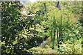
River Chelt behind Grovelands Close
Barely visible through the foliage, the River Chelt runs along the rear gardens in Grovelands Close.
Image: © Terry Jacombs
Taken: 23 May 2012
0.06 miles
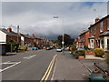
4
The view from Overbury Street, Charlton Kings
Image: © David Howard
Taken: 29 Jul 2013
0.10 miles
7
![Cheltenham houses [65]](https://s0.geograph.org.uk/geophotos/06/53/73/6537368_2f88faca_120x120.jpg)
Cheltenham houses [65]
Number 44 Cudnall Street is a substantial detached property, now flats.
Cheltenham is located at the foot of the Cotswold scarp with the small River Chelt flowing through the town. After the discovery of mineral springs in 1716 Cheltenham became a spa town and many Regency houses and other buildings were erected. The town is home to the renowned Cheltenham Festival, four days of horse jump racing culminating in the Gold Cup, held annually in March at the nearby racecourse.
Image: © Michael Dibb
Taken: 6 May 2020
0.11 miles
8
![Cheltenham houses [67]](https://s1.geograph.org.uk/geophotos/06/53/73/6537373_d73d4bc8_120x120.jpg)
Cheltenham houses [67]
Lexham Lodge is a mid 19th century house. It became offices in 1998 and a hospital in 2017. Listed, grade II, with details at: https://historicengland.org.uk/listing/the-list/list-entry/1386600
Cheltenham is located at the foot of the Cotswold scarp with the small River Chelt flowing through the town. After the discovery of mineral springs in 1716 Cheltenham became a spa town and many Regency houses and other buildings were erected. The town is home to the renowned Cheltenham Festival, four days of horse jump racing culminating in the Gold Cup, held annually in March at the nearby racecourse.
Image: © Michael Dibb
Taken: 6 May 2020
0.11 miles
9
![Cheltenham houses [85]](https://s0.geograph.org.uk/geophotos/06/54/38/6543808_d0fb401a_120x120.jpg)
Cheltenham houses [85]
Wraxall House in Brookway Road was built in 1816 for Sir Nathaniel Wraxall and his wife. There are many original internal features. Listed, grade II, with details at: https://historicengland.org.uk/listing/the-list/list-entry/1386559
Cheltenham is located at the foot of the Cotswold scarp with the small River Chelt flowing through the town. After the discovery of mineral springs in 1716 Cheltenham became a spa town and many Regency houses and other buildings were erected. The town is home to the renowned Cheltenham Festival, four days of horse jump racing culminating in the Gold Cup, held annually in March at the nearby racecourse.
Image: © Michael Dibb
Taken: 6 May 2020
0.11 miles
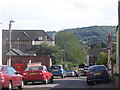
10
Cudnall Street at the junction of Overbury Street
Image: © David Howard
Taken: 29 Jul 2013
0.11 miles