IMAGES TAKEN NEAR TO
Emmanuel Gardens, CHELTENHAM, GL53 7NT
Introduction
This page details the photographs taken nearby to Emmanuel Gardens, GL53 7NT by members of the Geograph project.
The Geograph project started in 2005 with the aim of publishing, organising and preserving representative images for every square kilometre of Great Britain, Ireland and the Isle of Man.

There are currently over 7.5m images from over14,400 individuals and you can help contribute to the project by visiting https://www.geograph.org.uk
Image Map
Images are licensed for reuse under creativecommons.org/licenses/by-sa/2.0
Notes
- Clicking on the map will re-center to the selected point.
- The higher the marker number, the further away the image location is from the centre of the postcode.
Image Listing (70 Images Found)
Images are licensed for reuse under creativecommons.org/licenses/by-sa/2.0
Image
Details
Distance
1
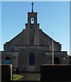
Emmanuel Church, Fairfield Parade
The church was built in 1936 replacing an earlier one.
Image: © Terry Jacombs
Taken: 18 Jan 2009
0.03 miles
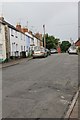
3
Fairhaven Street
This area of southern Cheltenham between Leckhampton Road and Naunton Park has several streets of early twentieth century housing.
Image: © Terry Jacombs
Taken: 4 Jul 2012
0.07 miles
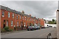
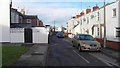
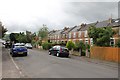
4
Naunton Crescent
This road of early 1900s housing is for the most part well and colourfully maintained. Sadly it is never seen to its best advantage as it always lined with cars which make it very difficult for traffic to pass vehicles travelling in the opposite direction.
Image: © Terry Jacombs
Taken: 20 Jan 2009
0.07 miles
5
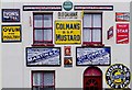
Hermitage Street, Cheltenham
An interesting image of a house much decorated with classic advertising signs from the earlier part of the twentieth century.
Image: © Roger May
Taken: 20 Nov 2012
0.08 miles
6
Fairfield Road
This area of southern Cheltenham between Leckhampton Road and Naunton Park has several streets of early twentieth century housing.
Image: © Terry Jacombs
Taken: 4 Jul 2012
0.09 miles
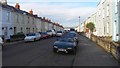
7
Hermitage Street
Hermitage Street is one of three narrow roads that lie between the Bath Road and Naunton Park mostly filled with early 1920s housing.
Image: © Terry Jacombs
Taken: 20 Jan 2009
0.09 miles
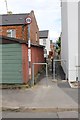
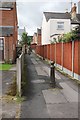
9
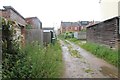
Rear Access to Houses
There are several alleys providing access to the rear of houses in this area. In this wet summer of 2012, the residents must be tired of the mud.
Image: © Terry Jacombs
Taken: 4 Jul 2012
0.12 miles
10
Fairfield Walk
This area of southern Cheltenham between Leckhampton Road and Naunton Park has several streets of early twentieth century housing.
Image: © Terry Jacombs
Taken: 4 Jul 2012
0.12 miles