IMAGES TAKEN NEAR TO
Bath Road, CHELTENHAM, GL53 7LX
Introduction
This page details the photographs taken nearby to Bath Road, GL53 7LX by members of the Geograph project.
The Geograph project started in 2005 with the aim of publishing, organising and preserving representative images for every square kilometre of Great Britain, Ireland and the Isle of Man.

There are currently over 7.5m images from over14,400 individuals and you can help contribute to the project by visiting https://www.geograph.org.uk
Image Map (Loading...)


Getting Data...Please wait
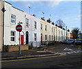
Leaflet Map data © OpenStreetMap
Images are licensed for reuse under creativecommons.org/licenses/by-sa/2.0
Notes
- Clicking on the map will re-center to the selected point.
- The higher the marker number, the further away the image location is from the centre of the postcode.
Image Listing (163 Images Found)
Images are licensed for reuse under creativecommons.org/licenses/by-sa/2.0
Image
Details
Distance
1
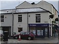
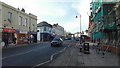
The Exmouth Arms, Cheltenham
Bath Road pub, opposite the Naunton Parade/Exmouth Street junction.
Image: © Jaggery
Taken: 25 Nov 2011
0.00 miles
2
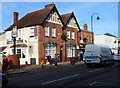
The Exmouth Arms
A busy pub in the middle of the Bath Road shopping area south of Cheltenham centre.
Image: © Terry Jacombs
Taken: 18 Jan 2009
0.02 miles
3
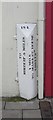
Old Milepost by the A46, Bath Road, Cheltenham
Cast iron post by the A46, in parish of Cheltenham (Cheltenham District), Bath Road, Moorend, 15m South of post office, against shop walls, on East side of road, opposite Upper Bath Street. Erected by the Birdlip (Second District) turnpike trust in the 19th century.
Inscription reads vertically:-
: TO / BIRDLIP 5 MILES : : 184 : : 1 MILE / TO MARKET HOUSE / CHELTNᴹ :
Milestone Society National ID: GL_CMBL01
Image: © M Faherty
Taken: 13 Mar 2011
0.02 miles
4
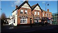
Bath Road, Cheltenham looking south from Bath Terrace
The Bath Road is a busy local shopping area south of Cheltenham centre
Image: © Terry Jacombs
Taken: 20 Jan 2009
0.02 miles
5
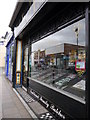
Bath Road Butchers
Bath Road Butchers. The Art Nouveau tiling is either side of the shop front
Image: © K K Stears
Taken: 12 Apr 2015
0.04 miles
6
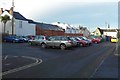
Bath Terrace Car Park, Cheltenham
The car park provides short term low cost car parking for shoppers in the Bath Road just to the east.
Image: © Terry Jacombs
Taken: 20 Jan 2009
0.04 miles
7
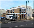
Lloyds TSB Bath Road Cheltenham branch
Bank branch at 189 Bath Road, on the corner of Suffolk Street.
Image: © Jaggery
Taken: 25 Nov 2011
0.06 miles
8
St Philip's Street, Cheltenham
Viewed from Norwood Road looking towards Bath Road.
On the left, the house with the red door is number 6 (Norwood Road).
The adjoining house (dark blue door) is number 23 (St Philip's Street).
Image: © Jaggery
Taken: 25 Nov 2011
0.07 miles
9
![Cheltenham houses [20]](https://s3.geograph.org.uk/geophotos/06/43/13/6431319_ffb99070_120x120.jpg)
Cheltenham houses [20]
The Coach House is early/mid 19th century with a nice Tuscan style porch. Listed, grade II, with details at: https://historicengland.org.uk/listing/the-list/list-entry/1386721
Cheltenham is located at the foot of the Cotswold scarp with the small River Chelt flowing through the town. After the discovery of mineral springs in 1716 Cheltenham became a spa town and many Regency houses and other buildings were erected. The town is home to the renowned Cheltenham Festival, four days of horse jump racing culminating in the Gold Cup, held annually in March at the nearby racecourse.
Image: © Michael Dibb
Taken: 12 Mar 2020
0.07 miles