IMAGES TAKEN NEAR TO
Shrublands, CHELTENHAM, GL53 0ND
Introduction
This page details the photographs taken nearby to Shrublands, GL53 0ND by members of the Geograph project.
The Geograph project started in 2005 with the aim of publishing, organising and preserving representative images for every square kilometre of Great Britain, Ireland and the Isle of Man.

There are currently over 7.5m images from over14,400 individuals and you can help contribute to the project by visiting https://www.geograph.org.uk
Image Map
Images are licensed for reuse under creativecommons.org/licenses/by-sa/2.0
Notes
- Clicking on the map will re-center to the selected point.
- The higher the marker number, the further away the image location is from the centre of the postcode.
Image Listing (56 Images Found)
Images are licensed for reuse under creativecommons.org/licenses/by-sa/2.0
Image
Details
Distance
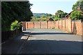
1
Newcourt Road
The old brick wall was originally the boundary of the Moorend Park Hotel grounds, long since replaced with a 1980s housing estate.
Image: © Terry Jacombs
Taken: 27 Jul 2012
0.05 miles
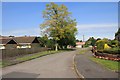
2
Charlton Close north end
Charlton Close is a quiet no through road of up market houses on the western side of Charlton Kings
Image: © Terry Jacombs
Taken: 27 Jul 2012
0.06 miles
3
New housing, Newcourt Road
Built in the 1990s on the site previously occupied by the Paragon Laundry.
Image: © Terry Jacombs
Taken: 27 Jul 2012
0.07 miles
4
Regis Close
Regis Close is part of a small 1960s development of up market detached properties on the western edge of Charlton Kings.
Image: © Terry Jacombs
Taken: 27 Jul 2012
0.08 miles
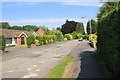
5
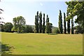
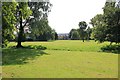
Newcourt Road Green
Newcourt Road Green is a public open triangle of land between Newcourt and Cirencester Roads.
Image: © Terry Jacombs
Taken: 27 Jul 2012
0.08 miles
6
Newcourt Road
The old brick wall was originally the boundary of the Moorend Park Hotel grounds, long since replaced with a 1980s housing estate.
Image: © Terry Jacombs
Taken: 27 Jul 2012
0.09 miles
7
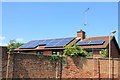
Solar Panels
Seen from Newcourt Road, an increasing number of homes around here are now sporting solar panels.
Image: © Terry Jacombs
Taken: 27 Jul 2012
0.09 miles
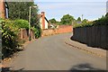
8
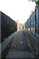
Path from Newcourt Road to Cirencester Road
Image: © Terry Jacombs
Taken: 27 Jul 2012
0.09 miles
9
Newcourt Road Green
Newcourt Road Green is a public open triangle of land between Newcourt and Cirencester Roads.
Image: © Terry Jacombs
Taken: 27 Jul 2012
0.09 miles
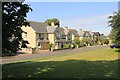
10
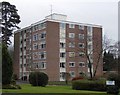
Withyholt Court, Moorend Road, Cheltenham
This 1960s development is not in keeping with the rest of the housing in this area. There is a second (identical) block behind and to the left of the one in the picture, partly hidden by trees.
Image: © Terry Jacombs
Taken: 23 Jan 2009
0.11 miles