
IMAGES TAKEN NEAR TO
Hobby Close, CHELTENHAM, GL53 0LP
Introduction
This page details the photographs taken nearby to Hobby Close, GL53 0LP by members of the Geograph project.
The Geograph project started in 2005 with the aim of publishing, organising and preserving representative images for every square kilometre of Great Britain, Ireland and the Isle of Man.

There are currently over 7.5m images from over14,400 individuals and you can help contribute to the project by visiting https://www.geograph.org.uk
Image Map
Images are licensed for reuse under creativecommons.org/licenses/by-sa/2.0
Notes
- Clicking on the map will re-center to the selected point.
- The higher the marker number, the further away the image location is from the centre of the postcode.
Image Listing (4 Images Found)
Images are licensed for reuse under creativecommons.org/licenses/by-sa/2.0
Image
Details
Distance
1
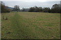
Farmland at Leckhampton
Field on the edge of the suburbs of Cheltenham.
Image: © Philip Halling
Taken: 29 Jan 2011
0.13 miles
2
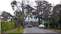
Cluster of trees, Moorend Park Road
The leafy suburb of Leckhampton, Cheltenham.
Image: © Jonathan Billinger
Taken: 20 Jan 2015
0.17 miles
3
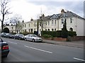
Leckhampton Road
Some of the many large Victorian houses that line the Leckhampton Road as it runs south from Cheltenham up to the Cotswold Escarpment.
Image: © Stephen Bowden
Taken: 16 Apr 2005
0.21 miles
4
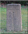
Old Boundary Marker
Municipal Boundary Marker on verge beside drive to house on south side of the A46 Shurdington Road. On the boundary between Cheltenham Borough and Leckhampton parish, Gloucestershire. Inscribed CHELTENHAM │ G C C (both vertical) on its centre face, with B OF C / 1935 above.
Milestone Society National ID: GL_LECCHE01pb
Image: © Mr Red
Taken: 22 Feb 2019
0.22 miles