IMAGES TAKEN NEAR TO
Leckhampton Place, CHELTENHAM, GL53 0FB
Introduction
This page details the photographs taken nearby to Leckhampton Place, GL53 0FB by members of the Geograph project.
The Geograph project started in 2005 with the aim of publishing, organising and preserving representative images for every square kilometre of Great Britain, Ireland and the Isle of Man.

There are currently over 7.5m images from over14,400 individuals and you can help contribute to the project by visiting https://www.geograph.org.uk
Image Map (Loading...)


Getting Data...Please wait
Leaflet Map data © OpenStreetMap
Images are licensed for reuse under creativecommons.org/licenses/by-sa/2.0
Notes
- Clicking on the map will re-center to the selected point.
- The higher the marker number, the further away the image location is from the centre of the postcode.
Image Listing (48 Images Found)
Images are licensed for reuse under creativecommons.org/licenses/by-sa/2.0
Image
Details
Distance
1
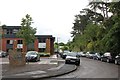
Old Station Drive
Built on the site of Leckhampton Station this is now a small business park. The original retaining wall is on the right hand side.
Image: © Terry Jacombs
Taken: 4 Jul 2012
0.03 miles
2
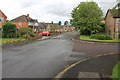
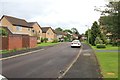
Southcourt Drive
Part of a small 1950s/1960s development on the eastern side of Leckhampton Road.
Image: © Terry Jacombs
Taken: 4 Jul 2012
0.04 miles
3
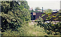
Site of Cheltenham South & Leckhampton station
View NW, towards Cheltenham (Lansdown and Hatherley Junctions): ex-GWR Cheltenham St James' - Andoversford - Kingham - Banbury line, also used by ex-M&SWJR trains from/to Andoversford from/to Cheltenham (Lansdown, later St James') - Cirencester - Swindon - Marlborough - Andover Junction. The latter ceased 11/9/61 and the station closed on 15/10/62 when the line to Kingham was closed. (Cf. Image]).
Image: © Ben Brooksbank
Taken: 7 May 1987
0.06 miles
4
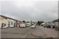
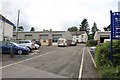
Mead Road Commercial Area
A builder's merchant and bathroom and kitchen store are among the businesses here.
Image: © Terry Jacombs
Taken: 4 Jul 2012
0.07 miles
5
Southcourt Close
Part of a small 1950s/1960s/1970s development on the eastern side of Leckhampton Road.
Image: © Terry Jacombs
Taken: 4 Jul 2012
0.08 miles
6
Maida Vale Road
The short road is bordered by several small businesses and leads to three or four small houses.
Image: © Terry Jacombs
Taken: 4 Jul 2012
0.09 miles
7
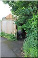
Mead Road to Old Bath Road footpath
Overgrown and muddy entrance in the wet summer of 2012
Image: © Terry Jacombs
Taken: 4 Jul 2012
0.09 miles
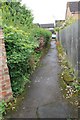
8
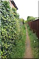
Footpath from Southcourt Drive to Pilley
Image: © Terry Jacombs
Taken: 4 Jul 2012
0.10 miles
10
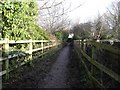
Footpath over the old Cheltenham to Banbury railway line
This footpath which links Mead Road to Bath Road runs through housing and small industrial premises and crosses this narrow bridge over the track of the long closed Cheltenham to Banbury railway line.
Image: © Terry Jacombs
Taken: 27 Jan 2009
0.11 miles