IMAGES TAKEN NEAR TO
Liddington Close, CHELTENHAM, GL53 0AH
Introduction
This page details the photographs taken nearby to Liddington Close, GL53 0AH by members of the Geograph project.
The Geograph project started in 2005 with the aim of publishing, organising and preserving representative images for every square kilometre of Great Britain, Ireland and the Isle of Man.

There are currently over 7.5m images from over14,400 individuals and you can help contribute to the project by visiting https://www.geograph.org.uk
Image Map
Images are licensed for reuse under creativecommons.org/licenses/by-sa/2.0
Notes
- Clicking on the map will re-center to the selected point.
- The higher the marker number, the further away the image location is from the centre of the postcode.
Image Listing (48 Images Found)
Images are licensed for reuse under creativecommons.org/licenses/by-sa/2.0
Image
Details
Distance
1
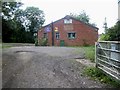
Liddington Road
Less than 50 yards long, Liddington Road does not go anywhere special.
Image: © Terry Jacombs
Taken: 23 Mar 2012
0.09 miles
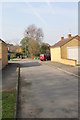
2
Pilley Crescent
A small 1930's estate on the south side of Cheltenham
Image: © Terry Jacombs
Taken: 23 Mar 2012
0.09 miles
3
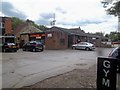
Business premises
A variety of businesses occupy these premises alongside Leckhampton Hill Road.
Image: © Michael Dibb
Taken: 23 Jul 2011
0.09 miles
4
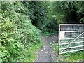
End of the path
The footpath down Leckhampton Hill effectively ends here where it meets the driveway to the village hall.
Image: © Michael Dibb
Taken: 23 Jul 2011
0.09 miles
5
Village Hall
The hall accommodates the local scouts and doubtless other groups in addition. Seen from the footpath.
Image: © Michael Dibb
Taken: 23 Jul 2011
0.10 miles
6
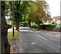
Tree-lined Leckhampton Road, Cheltenham
This part of Leckhampton Road is south of Pilley Lane.
Image: © Jaggery
Taken: 16 Sep 2018
0.11 miles
7
![Small sub-station [2]](https://s0.geograph.org.uk/geophotos/02/69/82/2698204_336853f4_120x120.jpg)
Small sub-station [2]
This small electrical sub-station is alongside the footpath.
Image: © Michael Dibb
Taken: 23 Jul 2011
0.11 miles
8
![Small sub-station [1]](https://s1.geograph.org.uk/geophotos/02/69/81/2698193_72a151e5_120x120.jpg)
Small sub-station [1]
This small electrical sub-station is alongside the footpath.
Image: © Michael Dibb
Taken: 23 Jul 2011
0.11 miles
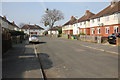
9
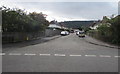
South along Pilley Crescent, Leckhampton, Cheltenham
Viewed across Pilley Lane from the corner of Hillands Drive.
Image: © Jaggery
Taken: 16 Sep 2018
0.12 miles
10
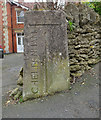
Old Boundary Marker
Municipal Boundary Marker on the southeast side of the junction of Leckhampton Road and Old Bath Road. On the boundary between Cheltenham Borough and Leckhampton parish, Gloucestershire. Inscribed CHELTENHAM │ G C C (both vertical) on its centre face, with B OF C / 1935 above.
Milestone Society National ID: GL_LECCHE02pb
Image: © Mr Red
Taken: 13 Mar 2019
0.13 miles