IMAGES TAKEN NEAR TO
Hope Mill Lane, London Road, STROUD, GL5 2SH
Introduction
This page details the photographs taken nearby to Hope Mill Lane, London Road, GL5 2SH by members of the Geograph project.
The Geograph project started in 2005 with the aim of publishing, organising and preserving representative images for every square kilometre of Great Britain, Ireland and the Isle of Man.

There are currently over 7.5m images from over14,400 individuals and you can help contribute to the project by visiting https://www.geograph.org.uk
Image Map
Images are licensed for reuse under creativecommons.org/licenses/by-sa/2.0
Notes
- Clicking on the map will re-center to the selected point.
- The higher the marker number, the further away the image location is from the centre of the postcode.
Image Listing (66 Images Found)
Images are licensed for reuse under creativecommons.org/licenses/by-sa/2.0
Image
Details
Distance
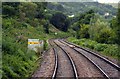
1
![The route of the Thames & Severn Canal [now a road]](https://s2.geograph.org.uk/geophotos/04/89/48/4894826_a4ed4656_120x120.jpg)
The route of the Thames & Severn Canal [now a road]
East of Hope Mill Lane, near Brimscombe. This section is in Phase 1A of the Cotswold Canals Trust's restoration programme. The Thames & Severn Way runs between the fence and the house.
Image: © Christine Johnstone
Taken: 28 Mar 2016
0.00 miles
3
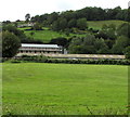
Hope Mills Business Centre, Brimscombe
The Business Centre is between the River Frome and the Thames & Severn Canal, viewed from London Road.
Image: © Jaggery
Taken: 6 Sep 2015
0.02 miles
4
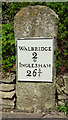
Milestone at Hope Mill
on the towpath between Hope Mill and Stroud Brewery.
Walbridge 2 / Inglesham 26¾
Milestone Society National ID: TSC-02
Image: © Mr Red
Taken: 30 Apr 2019
0.07 miles
5
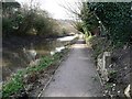
The Thames and Severn Way, north-west of Hope Mill Lane
Passing a Thames & Severn Canal milestone [minus its plate].
Image: © Christine Johnstone
Taken: 28 Mar 2016
0.07 miles
6
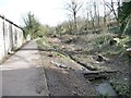
The Thames & Severn Canal, looking south-east
At the eastern end of the short infilled section, and just east of the site of Hope Mill Lock. This section is in Phase 1A of the Cotswold Canals Trust's restoration programme.
Image: © Christine Johnstone
Taken: 28 Mar 2016
0.08 miles
7
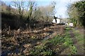
Silted up Thames and Severn Canal
A silted up section of the Thames and Severn Canal near Brimscombe.
Image: © Philip Halling
Taken: 30 Jan 2016
0.09 miles
8

Hope Mill Park, Thrupp
Park home site on a bank of the River Frome, alongside Hope Mill Lane. The river is on the left.
A park home is a detached bungalow-style house, usually in a private estate, as here, located on
plots known as pitches. Legally, they are mobile homes and are covered by their own legislation.
Image: © Jaggery
Taken: 6 Sep 2015
0.10 miles
9
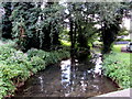
River Frome, Thrupp
Viewed from Hope Mill Lane below the A419 London Road. This River Frome is one of several rivers of that name in the SW of England. Frome is derived from an Old English word meaning fair, fine or brisk, describing the flow of a river, though "brisk" does not apply to this sluggish river today.
Image: © Jaggery
Taken: 6 Sep 2015
0.10 miles
10
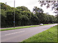
London Road layby, Thrupp
The layby extends for about 100 metres alongside the A419 London Road.
Image: © Jaggery
Taken: 6 Sep 2015
0.10 miles