IMAGES TAKEN NEAR TO
Bourne, Brimscombe, STROUD, GL5 2RH
Introduction
This page details the photographs taken nearby to GL5 2RH by members of the Geograph project.
The Geograph project started in 2005 with the aim of publishing, organising and preserving representative images for every square kilometre of Great Britain, Ireland and the Isle of Man.

There are currently over 7.5m images from over14,400 individuals and you can help contribute to the project by visiting https://www.geograph.org.uk
Image Map
Images are licensed for reuse under creativecommons.org/licenses/by-sa/2.0
Notes
- Clicking on the map will re-center to the selected point.
- The higher the marker number, the further away the image location is from the centre of the postcode.
Image Listing (92 Images Found)
Images are licensed for reuse under creativecommons.org/licenses/by-sa/2.0
Image
Details
Distance
1

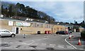
London Rd Brimscombe
This old petrol station has been converted to a hand car wash and is very prominent by its brash colours
Image: © Nigel Mykura
Taken: 7 Oct 2011
0.10 miles
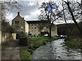
2
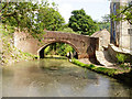
Thames and Severn Canal at Brimscombe
This is a very short watered section of the canal, which is either filled in or drained on either side. The building on the right is a former mill which I think is being converted into housing.
Image: © David Gruar
Taken: 7 Jun 2006
0.14 miles
3
Inside Football at Brimscombe Port
People now play football inside this former industrial shed.
Image: © Christine Johnstone
Taken: 28 Mar 2016
0.14 miles
4
Thames & Severn Canal, east end of Brimcombe Port
At the point where it crossed the boundary wall and entered the transhipment port.
Image: © Christine Johnstone
Taken: 28 Mar 2016
0.14 miles
5
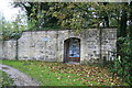
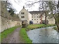
Former entrance to Brimscombe Port
Brimscombe Port on the Thames & Severn Canal has been filled in but was beyond this restored security door open in the surrounding wall. The port is due to be restored as part of the long-term plan to restore the through navigation. This location is by Bourne Mill - a very photogenic site between the canal and the railway.
Image: © Chris Allen
Taken: 27 Oct 2013
0.15 miles
6
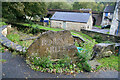
Entrance sign for Bourne Mill, Brimscombe
This engraved stone is by the entrance bridge over the Thames and Severn Canal. It states mills (plural) although sources list the site as Bourne Mill (singular). The derelict Thames and sebvern Canal is seen beyond the stone.
Image: © Chris Allen
Taken: 27 Oct 2013
0.15 miles
7
Port Industrial buildings by the River Frome
Image: © don cload
Taken: 13 Mar 2021
0.15 miles
8
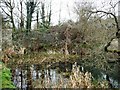
The River Frome downstream of Bourne Mill
Alongside, Brimscombe Port's boundary wall.
Image: © Christine Johnstone
Taken: 28 Mar 2016
0.16 miles
9
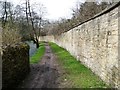
Southern boundary wall, Brimscombe Port
As a transhipment port, Brimscombe needed secure boundaries. This runs alongside the River Frome.
Image: © Christine Johnstone
Taken: 28 Mar 2016
0.16 miles
10
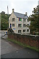
Bourne Mill, Brimscombe
A woollen manufacturing site probably dating back to the 17th century but rebuilt in the early 19th century. The site is very constrained by the River Frome, Thames & Severn Canal and the Great Western Railway Viaduct. In addition to textiles, the site was variously used for flock and walking stick manufacture. The site is now in multiple occupancy.
Image: © Chris Allen
Taken: 27 Oct 2013
0.16 miles