IMAGES TAKEN NEAR TO
Butterrow Lane, STROUD, GL5 2NQ
Introduction
This page details the photographs taken nearby to Butterrow Lane, GL5 2NQ by members of the Geograph project.
The Geograph project started in 2005 with the aim of publishing, organising and preserving representative images for every square kilometre of Great Britain, Ireland and the Isle of Man.

There are currently over 7.5m images from over14,400 individuals and you can help contribute to the project by visiting https://www.geograph.org.uk
Image Map (Loading...)


Getting Data...Please wait
Leaflet Map data © OpenStreetMap
Images are licensed for reuse under creativecommons.org/licenses/by-sa/2.0
Notes
- Clicking on the map will re-center to the selected point.
- The higher the marker number, the further away the image location is from the centre of the postcode.
Image Listing (53 Images Found)
Images are licensed for reuse under creativecommons.org/licenses/by-sa/2.0
Image
Details
Distance
1
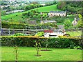
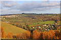
Towards the Frome valley, Stroud
The viewpoint is a public footpath. Moors Terrace http://www.geograph.org.uk/photo/1286610 can be seen at the upper right. At the upper left is the valley of the River Frome.
Image: © Brian Robert Marshall
Taken: 4 May 2009
0.02 miles
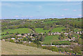
2
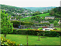
View from the footpath west of Butterrow
The village of Butterrow is a typical Cotswold mix of Victorian terraced and semi-detached properties and larger detached houses and bungalows. Its position midway up a valley with an east-facing aspect gives fine views.
Image: © Brian Robert Marshall
Taken: 4 May 2009
0.03 miles
3
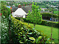
Footpath, Butterrow
The footpath leads down to Butterrow from the viewpoint at the left of the photograph.
Image: © Brian Robert Marshall
Taken: 4 May 2009
0.03 miles
4
View from a lorry
This is Bagpath Lane near Stroud, which has a 6'6" width limit, a 7.5 tonne weight limit and a tree canopy around ten feet above the road surface. I mention this because I was required to drive a 9' wide 18 tonne truck down here to deliver roof trusses which stood 16'2" above the surface of the road. So that was fun. Anyway, this was taken from the cab during one of many stops required to fold my side mirrors in to allow me to get past yet another obstruction.
Image: © John Winder
Taken: Unknown
0.04 miles
5
View from Rodborough Common
Looking over the valley towards Thrupp.
Image: © Wayland Smith
Taken: 14 Nov 2018
0.06 miles
6
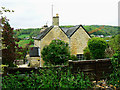
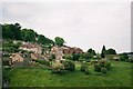
Moors Terrace, Butterrow
The terrace comprises four 'period' cottages. One of them is for sale at £255,000.
Image: © Brian Robert Marshall
Taken: 4 May 2009
0.08 miles
7
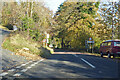
Entering Butter Row down Butterrow Hill
Image: © Robin Webster
Taken: 13 Nov 2022
0.08 miles
8
View from Roborough Common
View from Roborough Common towards Stroud.
Image: © Wayland Smith
Taken: 6 May 2013
0.09 miles
9
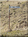
Fingerpost, Butterow Hill, Stroud
In the parish of Rodborough, on the lower slopes of the Common. Mount Vernon is a moderately sized private house, off this uncommitted road. It is a Listed Building see https://britishlistedbuildings.co.uk/101305481-mount-vernon-rodborough/maps#.YEeRhm-nwdU
Milestone Society National ID: GL_SO8503
Image: © Mr Red
Taken: 9 Mar 2021
0.09 miles
10
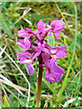
Orchid, Rodborough Common
There are said to be thirteen species of orchid on the common. This one could be an Early Purple. More here http://www.wildinthecotswolds.co.uk/index.php?option=com_content&task=view&id=240&Itemid=115
Image: © Brian Robert Marshall
Taken: 4 May 2009
0.12 miles