IMAGES TAKEN NEAR TO
Butterrow Lane, STROUD, GL5 2NL
Introduction
This page details the photographs taken nearby to Butterrow Lane, GL5 2NL by members of the Geograph project.
The Geograph project started in 2005 with the aim of publishing, organising and preserving representative images for every square kilometre of Great Britain, Ireland and the Isle of Man.

There are currently over 7.5m images from over14,400 individuals and you can help contribute to the project by visiting https://www.geograph.org.uk
Image Map
Images are licensed for reuse under creativecommons.org/licenses/by-sa/2.0
Notes
- Clicking on the map will re-center to the selected point.
- The higher the marker number, the further away the image location is from the centre of the postcode.
Image Listing (78 Images Found)
Images are licensed for reuse under creativecommons.org/licenses/by-sa/2.0
Image
Details
Distance
1
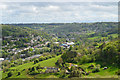
Bagpath, Thrupp and Brimscombe
From the heights of Rodborough Common.
Image: © Philip Pankhurst
Taken: 7 May 2014
0.03 miles
2
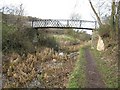
Jubilee Bridge
Restoration of this length of the Thames & Severn Canal was the first to be tackled by the then Stroudwater Canal Society, the forerunner of today's Cotswold Canal Trust, when they were formed in the 1970s. This bridge, with its unusual balustrades had previously been in a very poor state and was restored by the society's volunteers.
Image: © David Stowell
Taken: 30 Jan 2008
0.07 miles
3
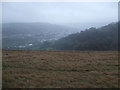
View from Rodborough Common in winter
Rodborough Common in winter is very different in aspect from the same place in the other seasons:then it reverts to its original character as wild, windy and desolate. This is the view from the summit looking towards Thrupp.
Image: © Vieve Forward
Taken: 30 Dec 2011
0.10 miles
4
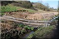
Wooden pontoon crossing
Wooden pontoon crossing across the silted Thames and Severn Canal, its purpose to enable an excavator to cross the canal to undertake dredging work.
Image: © Philip Halling
Taken: 30 Jan 2016
0.11 miles
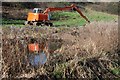
5
Silted canal
A silted section of the Thames and Severn Canal near Bagpath in the Stround valley.
Image: © Philip Halling
Taken: 30 Jan 2016
0.11 miles
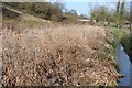
6
Silted Thames and Severn Canal
A section of overgrown and silted Thames and Severn Canal with an excavator on the far bank ready for further restoration work.
Image: © Philip Halling
Taken: 30 Jan 2016
0.12 miles
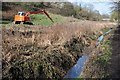
7
Excavator beside the Thames and Severn Canal
An excavator beside an overgrown and silted section of the Thames and Severn Canal.
Image: © Philip Halling
Taken: 30 Jan 2016
0.12 miles
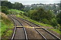
8
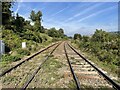
Ham Mill railway Halt (site), Gloucestershire
Opened in 1903 by the Great Western Railway on the line from Swindon to Gloucester, this station closed in 1964. Until 1957 it was known as "Ham Mill Crossing Halt".
View north towards Bowbridge Crossing and Gloucester, from a foot crossing. No trace appears to remain of the two short parallel platforms here.
Image: © Nigel Thompson
Taken: 9 Oct 2021
0.12 miles
9
Footpath crossing from Bagpath to Thrupp
Image: © Steve Daniels
Taken: 2 Sep 2009
0.12 miles
10
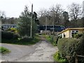
Level crossing, Ham Mill Lane
The train is heading towards Stroud.
Image: © Christine Johnstone
Taken: 28 Mar 2016
0.12 miles