IMAGES TAKEN NEAR TO
Bowbridge Lane, STROUD, GL5 2JN
Introduction
This page details the photographs taken nearby to Bowbridge Lane, GL5 2JN by members of the Geograph project.
The Geograph project started in 2005 with the aim of publishing, organising and preserving representative images for every square kilometre of Great Britain, Ireland and the Isle of Man.

There are currently over 7.5m images from over14,400 individuals and you can help contribute to the project by visiting https://www.geograph.org.uk
Image Map
Images are licensed for reuse under creativecommons.org/licenses/by-sa/2.0
Notes
- Clicking on the map will re-center to the selected point.
- The higher the marker number, the further away the image location is from the centre of the postcode.
Image Listing (56 Images Found)
Images are licensed for reuse under creativecommons.org/licenses/by-sa/2.0
Image
Details
Distance
1
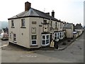
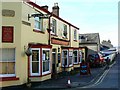
The Crown and Sceptre, Stroud
The Crown and Sceptre on Horns Road in Stroud.
Image: © Philip Halling
Taken: 12 Mar 2016
0.09 miles
2
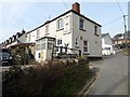
The Crown and Sceptre, Stroud
The Crown and Sceptre on the corner of Horns Road and Spider Lane in Stroud.
Image: © Philip Halling
Taken: 12 Mar 2016
0.09 miles
3
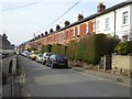
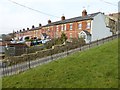
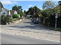
Horns Road, Stroud
A road of terrace houses likely to be from the turn of the twentieth century.
Image: © Philip Halling
Taken: 12 Mar 2016
0.09 miles
4
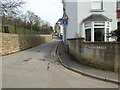
No through road to the Cemetery
I suppose it is somewhat fitting that this goes to the cemetery and is a 'no through road'.
Image: © Philip Halling
Taken: 12 Mar 2016
0.10 miles
5
The Crown and Sceptre, Horns Road, Stroud
One thing Stroud isn't short of is public houses. This one is a short distance to the south-west of the town's cemetery.
Image: © Brian Robert Marshall
Taken: 9 Feb 2008
0.10 miles
7
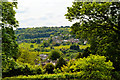
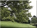
The view from the Cemetery
Mount Pleasant in the foreground, Bagpath in the distance.
Image: © Philip Pankhurst
Taken: 21 May 2014
0.12 miles
9
Park Road, Stroud
The SE end of Park Road viewed across the A419 London Road.
Image: © Jaggery
Taken: 6 Sep 2015
0.15 miles
10
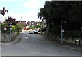
Bowbridge Lane, Stroud
A 20mph speed limit is in force along Bowbridge Lane.
Viewed across the A419 London Road from alongside the British Oak pub. http://www.geograph.org.uk/photo/4648912
Image: © Jaggery
Taken: 6 Sep 2015
0.16 miles