IMAGES TAKEN NEAR TO
Park Road, STROUD, GL5 2JG
Introduction
This page details the photographs taken nearby to Park Road, GL5 2JG by members of the Geograph project.
The Geograph project started in 2005 with the aim of publishing, organising and preserving representative images for every square kilometre of Great Britain, Ireland and the Isle of Man.

There are currently over 7.5m images from over14,400 individuals and you can help contribute to the project by visiting https://www.geograph.org.uk
Image Map (Loading...)


Getting Data...Please wait
Leaflet Map data © OpenStreetMap
Images are licensed for reuse under creativecommons.org/licenses/by-sa/2.0
Notes
- Clicking on the map will re-center to the selected point.
- The higher the marker number, the further away the image location is from the centre of the postcode.
Image Listing (83 Images Found)
Images are licensed for reuse under creativecommons.org/licenses/by-sa/2.0
Image
Details
Distance
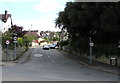
1
Park Road, Stroud
The SE end of Park Road viewed across the A419 London Road.
Image: © Jaggery
Taken: 6 Sep 2015
0.05 miles
2

Ford car sales
With their hatch boots open Fiestas and Focuses on a car sales forecourt near Stroud.
Image: © Philip Halling
Taken: 30 Jan 2016
0.09 miles
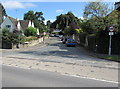
3
Bowbridge Lane, Stroud
A 20mph speed limit is in force along Bowbridge Lane.
Viewed across the A419 London Road from alongside the British Oak pub. http://www.geograph.org.uk/photo/4648912
Image: © Jaggery
Taken: 6 Sep 2015
0.09 miles
4
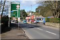
The A419 in the Stroud valley
The A419 in the Stroud valley between Thrupp and Stroud.
Image: © Philip Halling
Taken: 30 Jan 2016
0.09 miles
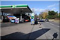
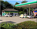
5
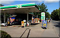
BP filling station in the southeast of Stroud
BP filling station and Shop'n'Drive shop located alongside the A419 London Road.
On Sunday September 6th 2015, regular unleaded petrol is 110.9 pence per litre.
Regular diesel is 109.9 pence per litre.
Image: © Jaggery
Taken: 6 Sep 2015
0.09 miles
6
Bowbridge electricity substation, Stroud
The Western Power Distribution electricity substation identifier is 10291 BOWBRIDGE. A caution notice on the wooden fence shows the presence of SF6 ( (sulphur hexafluoride, an insulating gas used in high voltage systems).
The location is alongside London Road in the southeast of Stroud, at the northern edge of Ashcroft House. http://www.geograph.org.uk/photo/4652062
Image: © Jaggery
Taken: 6 Sep 2015
0.09 miles
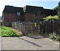
7
Ashcroft House, Stroud
Located alongside London Road near the Park Road junction, Ashcroft House contains 16 flats, built in 1988. Managed by Stroud District Council, Ashcroft House has a resident management staff and a community alarm service.
Image: © Jaggery
Taken: 6 Sep 2015
0.10 miles
8
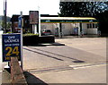
Jet Wash Centre in Stroud
At the southern edge of the London Road BP filling station.
Image: © Jaggery
Taken: 6 Sep 2015
0.10 miles
9
Car wash in the southeast of Stroud
Part of the BP filling station site alongside the A419 London Road.
Image: © Jaggery
Taken: 6 Sep 2015
0.11 miles