IMAGES TAKEN NEAR TO
Dallaway Estate, STROUD, GL5 2EB
Introduction
This page details the photographs taken nearby to Dallaway Estate, GL5 2EB by members of the Geograph project.
The Geograph project started in 2005 with the aim of publishing, organising and preserving representative images for every square kilometre of Great Britain, Ireland and the Isle of Man.

There are currently over 7.5m images from over14,400 individuals and you can help contribute to the project by visiting https://www.geograph.org.uk
Image Map
Images are licensed for reuse under creativecommons.org/licenses/by-sa/2.0
Notes
- Clicking on the map will re-center to the selected point.
- The higher the marker number, the further away the image location is from the centre of the postcode.
Image Listing (63 Images Found)
Images are licensed for reuse under creativecommons.org/licenses/by-sa/2.0
Image
Details
Distance
1
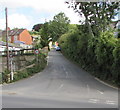
Brewery Lane, Thrupp
Ascending from the A419 London Road.
Image: © Jaggery
Taken: 6 Sep 2015
0.06 miles
2
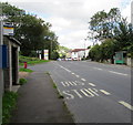
Two London Road bus shelters, Thrupp
Alongside the A419 London Road. The Hope Mill Lane junction http://www.geograph.org.uk/photo/4659454 is on the left.
Image: © Jaggery
Taken: 6 Sep 2015
0.06 miles
3
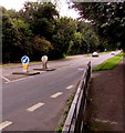
Pedestrian refuge, Thrupp
In the middle of the A419 London Road, SE of the Hope Mill Lane junction. http://www.geograph.org.uk/photo/4659454
Image: © Jaggery
Taken: 6 Sep 2015
0.07 miles
4
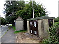
London Road gas installation and bus shelter, Thrupp
The London Road Wales & West Utilities (WWU) gas installation is on the corner of Hope Mill Lane. An EX in a black-lined yellow triangle indicates a potentially explosive atmosphere - smoking prohibited. A notice shows a WWU Plant Protection phone number to ring before beginning any works on, or within 10 metres of, this site.
Image: © Jaggery
Taken: 6 Sep 2015
0.07 miles
5
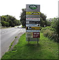
Hope Mills Business Centre nameboard, Thrupp
Alongside London Road on the approach to the Hope Mill Lane junction.
Typographical errors on the board include Pheonix for Phoenix and Piano's for Pianos.
Image: © Jaggery
Taken: 6 Sep 2015
0.07 miles
6
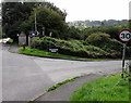
NE end of Hope Mill Lane, Thrupp
Hope Mill Lane ascends from the valley of the River Frome towards the A419 London Road.
Thrupp Industrial Estate electricity substation http://www.geograph.org.uk/photo/4659473 and a yellow grit box are on the left.
Image: © Jaggery
Taken: 6 Sep 2015
0.07 miles
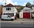
7
Renofix London Road Garage, Thrupp
Vehicle servicing, repairs and sales business on the corner of London Road and Brewery Lane.
Image: © Jaggery
Taken: 6 Sep 2015
0.07 miles
8
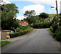
Junction of London Road and Hope Mill Lane, Thrupp
Hope Mill Lane descends from the A419 London Road towards Hope Mills Business Centre and the River Frome.
Image: © Jaggery
Taken: 6 Sep 2015
0.08 miles
9
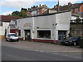
Old Post Office, Thrupp
The van and red pillarbox are alongside the house which used to be Thrupp post office.
Thrupp Service Centre is on the right.
Image: © Jaggery
Taken: 6 Sep 2015
0.08 miles
10
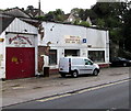
Thrupp Service Centre, Thrupp
The London Road garage on the left is next door to Renofix London Road Garage.
Image: © Jaggery
Taken: 6 Sep 2015
0.08 miles