IMAGES TAKEN NEAR TO
Gunhouse Lane, STROUD, GL5 2DB
Introduction
This page details the photographs taken nearby to Gunhouse Lane, GL5 2DB by members of the Geograph project.
The Geograph project started in 2005 with the aim of publishing, organising and preserving representative images for every square kilometre of Great Britain, Ireland and the Isle of Man.

There are currently over 7.5m images from over14,400 individuals and you can help contribute to the project by visiting https://www.geograph.org.uk
Image Map
Images are licensed for reuse under creativecommons.org/licenses/by-sa/2.0
Notes
- Clicking on the map will re-center to the selected point.
- The higher the marker number, the further away the image location is from the centre of the postcode.
Image Listing (74 Images Found)
Images are licensed for reuse under creativecommons.org/licenses/by-sa/2.0
Image
Details
Distance
1
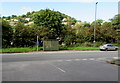
London Road bus stop and shelter, Bowbridge, Stroud
Alongside the A419 London Road, opposite Thrupp Lane. http://www.geograph.org.uk/photo/4649284
Image: © Jaggery
Taken: 6 Sep 2015
0.05 miles
2
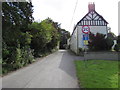
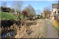
Gunhouse Lane, Bowbridge, Stroud
Dead-end lane viewed from the A419 London Road.
Image: © Jaggery
Taken: 6 Sep 2015
0.06 miles
3
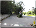
Thrupp Lane, Stroud
At the southern edge of Stroud, Thrupp Lane on the left diverges from the A419 London Road.
The Thrupp village boundary sign http://www.geograph.org.uk/photo/4654543 alongside London Road is nearby (ahead).
Image: © Jaggery
Taken: 6 Sep 2015
0.07 miles
4
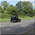
Vintage Austin car heads into Stroud
On the A419 London Road at the SE edge of Stroud.
Image: © Jaggery
Taken: 6 Sep 2015
0.07 miles
5
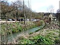
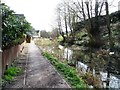
The River Frome near Bowbridge Lock
Looking upstream [locally south].
Image: © Christine Johnstone
Taken: 28 Mar 2016
0.08 miles
6
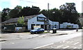
Topps Tiles, Bowbridge, Stroud
Sellers of tiles, natural stone and wood flooring, adhesives & accessories
located on the corner of the A419 London Road and Gunhouse Lane.
A Stagecoach in the Cotswolds bus depot entrance http://www.geograph.org.uk/photo/4649226 is on the left.
Image: © Jaggery
Taken: 6 Sep 2015
0.10 miles
7
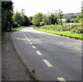
Bowbridge bus stop near the Thrupp village boundary sign, Stroud
Long bus stop alongside the A419 London Road at the SE edge of Stroud.
The Welcome to Thrupp sign http://www.geograph.org.uk/photo/4654543 is in the background.
Image: © Jaggery
Taken: 6 Sep 2015
0.11 miles
8
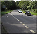
Old-timer leaves Thrupp
A vintage Austin car on the A419 London enters Stroud from the village of Thrupp.
Image: © Jaggery
Taken: 6 Sep 2015
0.11 miles
9
The disused Thames and Severn Canal
The disused Thames and Severn Canal north of Stanton's Bridge near Thrupp.
Image: © Philip Halling
Taken: 30 Jan 2016
0.11 miles
10
The Thames & Severn Canal above Bowbridge Lock
Despite what the online OS map says, this is the Thames & Severn Canal, not the Stroudwater Canal.
Image: © Christine Johnstone
Taken: 28 Mar 2016
0.11 miles