IMAGES TAKEN NEAR TO
Bozards Lane, Gotherington Fields, CHELTENHAM, GL52 9SD
Introduction
This page details the photographs taken nearby to Bozards Lane, Gotherington Fields, GL52 9SD by members of the Geograph project.
The Geograph project started in 2005 with the aim of publishing, organising and preserving representative images for every square kilometre of Great Britain, Ireland and the Isle of Man.

There are currently over 7.5m images from over14,400 individuals and you can help contribute to the project by visiting https://www.geograph.org.uk
Image Map (Loading...)


Getting Data...Please wait
Leaflet Map data © OpenStreetMap
Images are licensed for reuse under creativecommons.org/licenses/by-sa/2.0
Notes
- Clicking on the map will re-center to the selected point.
- The higher the marker number, the further away the image location is from the centre of the postcode.
Image Listing (9 Images Found)
Images are licensed for reuse under creativecommons.org/licenses/by-sa/2.0
Image
Details
Distance
1

Bird of prey hovering over Bozard's lane
A hawk(?) has spotted something in the roadside of this narrow Gloucestershire lane.
Image: © Jonathan Billinger
Taken: 20 Oct 2014
0.05 miles
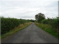
2
Field entrance west of Woolstone
Into a field of Maize.
Image: © JThomas
Taken: 13 Aug 2021
0.05 miles
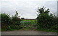
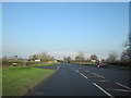
3
Bozard Lane
Heading for Bozard's Farm amongst other places.
Image: © Des Blenkinsopp
Taken: 26 Jun 2018
0.06 miles
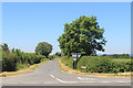
5
Cereal crop west of Woolstone
Towards the A435.
Image: © JThomas
Taken: 13 Aug 2021
0.09 miles
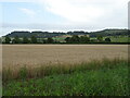
6
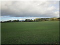
Autumn sown crop near Woolstone
The Cotswold edge catching the afternoon sun.
Image: © Jonathan Thacker
Taken: 5 Oct 2022
0.12 miles
8
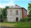
Old Toll House by Evesham Road, Woolstone
Toll House in the parish of Oxenton (Tewkesbury District), Pike House, Evesham Road (A435), Woolstone, GL52 8SD.
Gloucester County Council.
HER 5493 https://www.heritagegateway.org.uk/Gateway/Results_Single.aspx?uid=5493&resourceID=108
Surveyed
Milestone Society National ID: GL.OXE
Image: © Alan Rosevear
Taken: Unknown
0.18 miles
9
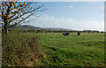
Cattle Field Near Gotherington
An October view of good grazing land with the Cotswold hills in the background.
Image: © Mary and Angus Hogg
Taken: 16 Oct 2017
0.21 miles