IMAGES TAKEN NEAR TO
Tobyfield Road, CHELTENHAM, GL52 8NY
Introduction
This page details the photographs taken nearby to Tobyfield Road, GL52 8NY by members of the Geograph project.
The Geograph project started in 2005 with the aim of publishing, organising and preserving representative images for every square kilometre of Great Britain, Ireland and the Isle of Man.

There are currently over 7.5m images from over14,400 individuals and you can help contribute to the project by visiting https://www.geograph.org.uk
Image Map
Images are licensed for reuse under creativecommons.org/licenses/by-sa/2.0
Notes
- Clicking on the map will re-center to the selected point.
- The higher the marker number, the further away the image location is from the centre of the postcode.
Image Listing (16 Images Found)
Images are licensed for reuse under creativecommons.org/licenses/by-sa/2.0
Image
Details
Distance
1
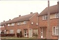
Linworth Road
Linworth Road is in Cleeve Estate. This was built from 1950 onwards to house workers at Smiths Industries. It was built as a garden suburb at a time when few people owned cars and so no provision was made. In this picture, from 1977, few cars are in evidence but go there today, and a visitor can hardly move without falling over them.
Image: © Tenikwa
Taken: 14 Aug 1977
0.16 miles
2
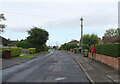
Kayte Lane, Bishop's Cleeve
Showing position of Postbox No. GL52 327.
See Image] for postbox.
Image: © JThomas
Taken: 13 Aug 2021
0.18 miles
4
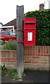
Elizabeth II postbox on Kayte Lane, Bishop's Cleeve
Postbox No. GL52 327.
See Image] for context.
Image: © JThomas
Taken: 13 Aug 2021
0.19 miles
5
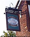
The Swallow Inn (3) - sign, Bishop's Drive, Bishop's Cleeve, Glos
The sign is very badly faded but there is still enough detail to see that the pub is named after a sailing ship, not a bird. What connection, if any, there is with Bishop's Cleeve is unknown. On the other side, the image of the ship has faded to invisibility.
Image
Image
Image: © P L Chadwick
Taken: 6 Apr 2013
0.19 miles
6
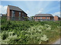
New housing on Jesson Road, Bishop's Cleeve
Alongside the Gloucestershire Warwickshire Steam Railway.
Image: © Christine Johnstone
Taken: 7 Jul 2019
0.19 miles
7
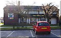
The Swallow Inn (2), Bishop's Drive, Bishop's Cleeve, Glos
Image: © P L Chadwick
Taken: 6 Apr 2013
0.19 miles
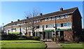
8
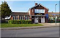
The Swallow Inn (1), Bishop's Drive, Bishop's Cleeve, Glos
This fairly modern looking building probably started out as an estate pub in this large village, which has a small number of pubs in relation to its population figure. Today it is both a pub and a Cantonese restaurant. To the right of the pub is a car park and behind that a parade of shops.
Image
Image
Image: © P L Chadwick
Taken: 6 Apr 2013
0.20 miles
9
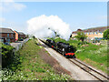
Gloucestershire Warwickshire Railway at Bishop's Cleeve
Visiting U class locomotive No. 31806 and Manor class No. 7820 pass Bishop's Cleeve during the Gloucestershire Warwickshire Railway's steam gala.
Image: © Gareth James
Taken: 13 May 2023
0.21 miles
10
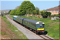
Gloucestershire & Warwickshire Railway
Diesel train on the Gloucestershire & Warwickshire Railway passing Bishops Cleeve.
Image: © Wayland Smith
Taken: 21 Apr 2019
0.21 miles