IMAGES TAKEN NEAR TO
Pember Close, GL52 8GP
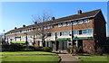
Introduction
This page details the photographs taken nearby to Pember Close, GL52 8GP by members of the Geograph project.
The Geograph project started in 2005 with the aim of publishing, organising and preserving representative images for every square kilometre of Great Britain, Ireland and the Isle of Man.

There are currently over 7.5m images from over14,400 individuals and you can help contribute to the project by visiting https://www.geograph.org.uk
Image Map
Images are licensed for reuse under creativecommons.org/licenses/by-sa/2.0
Notes
- Clicking on the map will re-center to the selected point.
- The higher the marker number, the further away the image location is from the centre of the postcode.
Image Listing (116 Images Found)
Images are licensed for reuse under creativecommons.org/licenses/by-sa/2.0
Image
Details
Distance
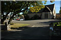
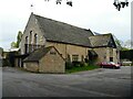
1
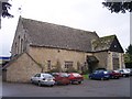
Tithe Barn Village Hall, Bishop's Cleeve
In the centre of this ever expanding village opposite Cleeve Hall.
Image: © Bob Embleton
Taken: 10 Nov 2005
0.07 miles
2
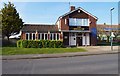
The Swallow Inn (1), Bishop's Drive, Bishop's Cleeve, Glos
This fairly modern looking building probably started out as an estate pub in this large village, which has a small number of pubs in relation to its population figure. Today it is both a pub and a Cantonese restaurant. To the right of the pub is a car park and behind that a parade of shops.
Image
Image
Image: © P L Chadwick
Taken: 6 Apr 2013
0.08 miles
3
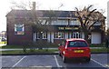
The Swallow Inn (2), Bishop's Drive, Bishop's Cleeve, Glos
Image: © P L Chadwick
Taken: 6 Apr 2013
0.08 miles
4
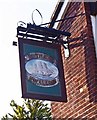
The Swallow Inn (3) - sign, Bishop's Drive, Bishop's Cleeve, Glos
The sign is very badly faded but there is still enough detail to see that the pub is named after a sailing ship, not a bird. What connection, if any, there is with Bishop's Cleeve is unknown. On the other side, the image of the ship has faded to invisibility.
Image
Image
Image: © P L Chadwick
Taken: 6 Apr 2013
0.08 miles
6
The Tithe Barn, Bishop's Cleeve
The tithe barn at Bishop's Cleeve is now used as a village hall.
Image: © Philip Halling
Taken: 11 Oct 2008
0.11 miles
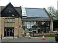
7
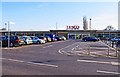
Tesco, Church Road, Bishop's Cleeve, Glos
A large Tesco, branded a "superstore". The address is Church Walk but it is actually behind the south side of that road, accessed from a service road.
Image: © P L Chadwick
Taken: 6 Apr 2013
0.12 miles
8
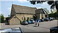
The Old Tithe Barn
https://historicengland.org.uk/listing/the-list/list-entry/1340152?section=official-list-entry
Image: © Sandy Gerrard
Taken: 11 May 2024
0.13 miles
9
Bishop's Cleeve buildings [3]
This former tithe barn in Cheltenham Road is now used as the village hall. Probably built in the early 15th century as the tithe barn for the Bishop of Worcester at Cleeve Hall. Partly destroyed by fire in the late 19th century, the barn was altered and restored and reopened as a village hall in 1956. Recently an extension has provided a lift, two new meeting rooms, a new kitchen and other facilities. Constructed of squared, coursed limestone with a stone slate roof. There is a history of the barn at: https://www.cleevetithebarn.org.uk/History Listed, grade II, with details at: https://historicengland.org.uk/listing/the-list/list-entry/1340152
Bishop's Cleeve is a large village in Gloucestershire. It lies at the foot of Cleeve Hill, the highest point of the Cotswolds, some 3½ miles north of Cheltenham. Although Iron Age and Roman remains have been found locally, the earliest known origins of the village date to the 8th Century. A monastery and surrounding land was given to the Bishop of Worcester, and the village became the Bishop’s Cliffe. The village grew rapidly when an aerospace factory was built nearby after the Second World War and continues to grow.
Image: © Michael Dibb
Taken: 9 Nov 2021
0.13 miles
10
Bishop's Cleeve buildings [4]
This former tithe barn in Cheltenham Road is now used as the village hall. Probably built in the early 15th century as the tithe barn for the Bishop of Worcester at Cleeve Hall. Partly destroyed by fire in the late 19th century, the barn was altered and restored and reopened as a village hall in 1956. Recently an extension has provided a lift, two new meeting rooms, a new kitchen and other facilities. Constructed of squared, coursed limestone with a stone slate roof. There is a history of the barn at: https://www.cleevetithebarn.org.uk/History Listed, grade II, with details at: https://historicengland.org.uk/listing/the-list/list-entry/1340152
Bishop's Cleeve is a large village in Gloucestershire. It lies at the foot of Cleeve Hill, the highest point of the Cotswolds, some 3½ miles north of Cheltenham. Although Iron Age and Roman remains have been found locally, the earliest known origins of the village date to the 8th Century. A monastery and surrounding land was given to the Bishop of Worcester, and the village became the Bishop’s Cliffe. The village grew rapidly when an aerospace factory was built nearby after the Second World War and continues to grow.
Image: © Michael Dibb
Taken: 9 Nov 2021
0.13 miles