IMAGES TAKEN NEAR TO
Cowslip Drive, CHELTENHAM, GL52 8ET
Introduction
This page details the photographs taken nearby to Cowslip Drive, GL52 8ET by members of the Geograph project.
The Geograph project started in 2005 with the aim of publishing, organising and preserving representative images for every square kilometre of Great Britain, Ireland and the Isle of Man.

There are currently over 7.5m images from over14,400 individuals and you can help contribute to the project by visiting https://www.geograph.org.uk
Image Map (Loading...)


Getting Data...Please wait
Leaflet Map data © OpenStreetMap
Images are licensed for reuse under creativecommons.org/licenses/by-sa/2.0
Notes
- Clicking on the map will re-center to the selected point.
- The higher the marker number, the further away the image location is from the centre of the postcode.
Image Listing (5 Images Found)
Images are licensed for reuse under creativecommons.org/licenses/by-sa/2.0
Image
Details
Distance
1
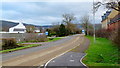
The Old Evesham Road
Looking south towards the dormitory town of Bishop's Cleeve and the Cotswold scarp beyond.
Image: © Jonathan Billinger
Taken: 25 Jan 2012
0.15 miles
2
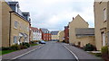
Greenacre Way, Bishop's Cleeve
Recently built townscape-style housing on the northern edge of this dormitory town.
Image: © Jonathan Billinger
Taken: 25 Jan 2012
0.18 miles
3
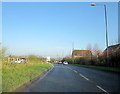
Approaching The End of Bishop's Cleeve By-Pass Northbound
Image: © Roy Hughes
Taken: 29 Nov 2014
0.20 miles
4
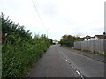
Evesham Road, Bishop's Cleeve
Looking north on the former A435.
Image: © JThomas
Taken: 13 Aug 2021
0.21 miles
5
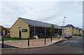
Co-operative food store on Vale Road, Bishop's Cleeve
Image: © JThomas
Taken: 13 Aug 2021
0.25 miles