IMAGES TAKEN NEAR TO
Stoke Road, CHELTENHAM, GL52 7RS
Introduction
This page details the photographs taken nearby to Stoke Road, GL52 7RS by members of the Geograph project.
The Geograph project started in 2005 with the aim of publishing, organising and preserving representative images for every square kilometre of Great Britain, Ireland and the Isle of Man.

There are currently over 7.5m images from over14,400 individuals and you can help contribute to the project by visiting https://www.geograph.org.uk
Image Map
Images are licensed for reuse under creativecommons.org/licenses/by-sa/2.0
Notes
- Clicking on the map will re-center to the selected point.
- The higher the marker number, the further away the image location is from the centre of the postcode.
Image Listing (5 Images Found)
Images are licensed for reuse under creativecommons.org/licenses/by-sa/2.0
Image
Details
Distance
1
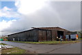
WW2 Bellman hangar at former RAF Stoke Orchard
This is a 'Bellman' hangar- the last remaining of 4 that were originally built at RAF Stoke Orchard in 1940-41 in an area today known as 'The Park'. Initially a RLG (Relief Landing Ground) RAF Stoke Orchard soon became a training airfield with the arrival of the No.10 Elementary Flying Training School in September 1941 and records indicate 50 Tiger Moths were based here. From the summer of 1942 the airfield specialised in the training of glider pilots and instructors. The hangar today still bearing signs of its wartime camouflage is now used by a specialist recycling company.
Image: © Roger Davies
Taken: 11 Apr 2008
0.05 miles
2
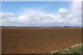
Arable land near Stoke Orchard
View looks north-westwards towards the village of Stoke Orchard from a spot on the old airfield perimeter track near 'The Park'. The Malverns are visible in the distance on the right. This flat area now under arable cultivation was formerly the grass landing air strip of RAF Stoke Orchard between 1940 and 1946.
Image: © Roger Davies
Taken: 11 Apr 2008
0.18 miles
3
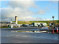
Wingmoor Landfill Site
Operated by Grundon; see http://www.environment-agency.gov.uk/homeandleisure/waste/121847.aspx
Image: © Jonathan Billinger
Taken: 8 Nov 2010
0.21 miles
4

Stoke Orchard HRC (Household Recycling Centre)
Image: © Roger Davies
Taken: 11 Apr 2008
0.22 miles