IMAGES TAKEN NEAR TO
Coltham Road, CHELTENHAM, GL52 6RP
Introduction
This page details the photographs taken nearby to Coltham Road, GL52 6RP by members of the Geograph project.
The Geograph project started in 2005 with the aim of publishing, organising and preserving representative images for every square kilometre of Great Britain, Ireland and the Isle of Man.

There are currently over 7.5m images from over14,400 individuals and you can help contribute to the project by visiting https://www.geograph.org.uk
Image Map
Images are licensed for reuse under creativecommons.org/licenses/by-sa/2.0
Notes
- Clicking on the map will re-center to the selected point.
- The higher the marker number, the further away the image location is from the centre of the postcode.
Image Listing (46 Images Found)
Images are licensed for reuse under creativecommons.org/licenses/by-sa/2.0
Image
Details
Distance
1
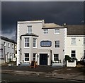
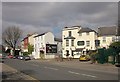
The Beaufort Arms
The Beaufort Arms has reopened, after a two and a half year period of closure. The former B&B has undergone a major refurbishment. What was once a traditional pub with a skittle alley, is now a modern bar and restaurant.
Image: © Helen Iwanczuk
Taken: 23 Feb 2020
0.09 miles
2
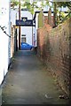
Alleyway from London Road to Upper Park Street
Also provides access to the Cheltenham Motor Club, surprisingly a favourite watering hole of the Cheltenham branch of the Cyclists' Touring Club.
Image: © Terry Jacombs
Taken: 23 May 2012
0.09 miles
3
The Beaufort Arms, London Road
Still largely a traditional pub.
Image: © Terry Jacombs
Taken: 23 May 2012
0.10 miles
4
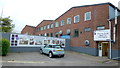
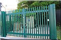
The Kitchen Workshop, Cheltenham
Business on King Alfred's Way, Battledown Trading Estate.
Image: © Jonathan Billinger
Taken: 27 Aug 2014
0.10 miles
5
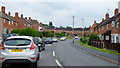
Churchill Drive, Cheltenham
1950's council housing on the eastern edge of the town.
Image: © Jonathan Billinger
Taken: 27 Aug 2014
0.11 miles
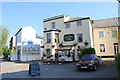
6
Beaufort Arms, Cheltenham
A wider view of Image, taken looking across the A40.
Image: © Derek Harper
Taken: 21 Mar 2015
0.11 miles
8
Ewen's Road, Cheltenham
1950's council housing on the eastern edge of the town.
Image: © Jonathan Billinger
Taken: 27 Aug 2014
0.11 miles
9
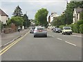
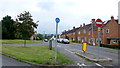
A40 (London Road) approaching central Cheltenham
Image: © Peter Whatley
Taken: 21 May 2011
0.11 miles
10
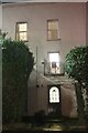
Georgian house on Sandford Mill Road, Cheltenham
Image: © David Howard
Taken: 15 Feb 2024
0.12 miles