IMAGES TAKEN NEAR TO
King Alfred Way, CHELTENHAM, GL52 6QP
Introduction
This page details the photographs taken nearby to King Alfred Way, GL52 6QP by members of the Geograph project.
The Geograph project started in 2005 with the aim of publishing, organising and preserving representative images for every square kilometre of Great Britain, Ireland and the Isle of Man.

There are currently over 7.5m images from over14,400 individuals and you can help contribute to the project by visiting https://www.geograph.org.uk
Image Map
Images are licensed for reuse under creativecommons.org/licenses/by-sa/2.0
Notes
- Clicking on the map will re-center to the selected point.
- The higher the marker number, the further away the image location is from the centre of the postcode.
Image Listing (35 Images Found)
Images are licensed for reuse under creativecommons.org/licenses/by-sa/2.0
Image
Details
Distance
1
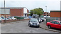
Battledown Trading Estate, Cheltenham
Light industry on Cheltenham's eastern edge.
Image: © Jonathan Billinger
Taken: 27 Aug 2014
0.03 miles
2
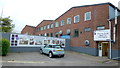
The Kitchen Workshop, Cheltenham
Business on King Alfred's Way, Battledown Trading Estate.
Image: © Jonathan Billinger
Taken: 27 Aug 2014
0.04 miles
4
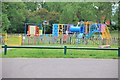
Gueen Elizabeth playing fields, playground
Image: © Terry Jacombs
Taken: 29 May 2012
0.09 miles
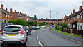
5
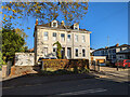
Houses on Sydenham Road North, Cheltenham
The last pair at the Hales Road end.
Image: © Robin Webster
Taken: 13 Nov 2022
0.10 miles
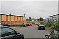
6
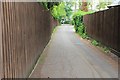
Haywards Lane
A short no through lane just off Battledown Approach.
Image: © Terry Jacombs
Taken: 29 May 2012
0.12 miles
7
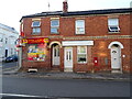
Off Licence and houses on Hales Road, Cheltenham
Showing position of Postbox No. GL52 63.
See Image] for postbox.
Image: © JThomas
Taken: 12 Aug 2021
0.13 miles
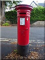
8
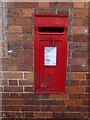
Elizabeth II postbox on Hales Road, Cheltenham
Postbox No. GL52 63.
See Image] for context.
Image: © JThomas
Taken: 12 Aug 2021
0.13 miles
9
Victorian postbox on Battledown Approach, Cheltenham
Postbox No. GL52 47.
See Image] for context.
Image: © JThomas
Taken: 12 Aug 2021
0.13 miles
10
Ewen's Road, Cheltenham
1950's council housing on the eastern edge of the town.
Image: © Jonathan Billinger
Taken: 27 Aug 2014
0.13 miles