IMAGES TAKEN NEAR TO
Ashley Close, CHELTENHAM, GL52 6LE
Introduction
This page details the photographs taken nearby to Ashley Close, GL52 6LE by members of the Geograph project.
The Geograph project started in 2005 with the aim of publishing, organising and preserving representative images for every square kilometre of Great Britain, Ireland and the Isle of Man.

There are currently over 7.5m images from over14,400 individuals and you can help contribute to the project by visiting https://www.geograph.org.uk
Image Map (Loading...)


Getting Data...Please wait
Leaflet Map data © OpenStreetMap
Images are licensed for reuse under creativecommons.org/licenses/by-sa/2.0
Notes
- Clicking on the map will re-center to the selected point.
- The higher the marker number, the further away the image location is from the centre of the postcode.
Image Listing (22 Images Found)
Images are licensed for reuse under creativecommons.org/licenses/by-sa/2.0
Image
Details
Distance
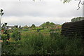
1
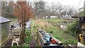
Allotments, Ryeworth, Cheltenham
A misty morning but activity is evident.
Image: © Jonathan Billinger
Taken: 19 Mar 2020
0.05 miles
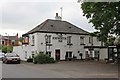
4
The Ryeworth Inn
The Ryeworth Inn on Ryeworth Road in Cheltenham.
Image: © Philip Halling
Taken: 5 Dec 2010
0.11 miles
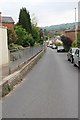
6
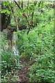
Ham Brook
The stream runs along the rear of gardens in Ham here.
Image: © Terry Jacombs
Taken: 29 May 2012
0.18 miles
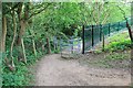
8
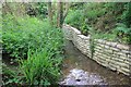
Ham Brook
The stream runs along the rear of gardens in Ham here.
Image: © Terry Jacombs
Taken: 29 May 2012
0.20 miles
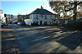
9
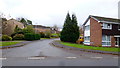
Warwick Crescent
1970's housing in the Cheltenham suburb of Charlton Kings.
Image: © Jonathan Billinger
Taken: 12 Dec 2014
0.20 miles
10
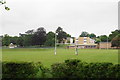
St Edward's Preparatory School
An independent Catholic school.
Image: © Bill Boaden
Taken: 25 May 2018
0.20 miles