IMAGES TAKEN NEAR TO
Charlton Court Road, CHELTENHAM, GL52 6JB
Introduction
This page details the photographs taken nearby to Charlton Court Road, GL52 6JB by members of the Geograph project.
The Geograph project started in 2005 with the aim of publishing, organising and preserving representative images for every square kilometre of Great Britain, Ireland and the Isle of Man.

There are currently over 7.5m images from over14,400 individuals and you can help contribute to the project by visiting https://www.geograph.org.uk
Image Map (Loading...)


Getting Data...Please wait
Leaflet Map data © OpenStreetMap
Images are licensed for reuse under creativecommons.org/licenses/by-sa/2.0
Notes
- Clicking on the map will re-center to the selected point.
- The higher the marker number, the further away the image location is from the centre of the postcode.
Image Listing (75 Images Found)
Images are licensed for reuse under creativecommons.org/licenses/by-sa/2.0
Image
Details
Distance
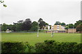
1
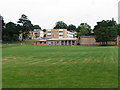
St.Edwards Preparatory and Junior School, Charlton Kings
Previously Whitefriars school, it merged with St Edward's school at Charlton Park Convent where the senior school is based in the 1980/1990s. It is an independent Catholic based school.
Image: © Terry Jacombs
Taken: 4 Aug 2005
0.12 miles
2
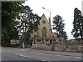
Holy Apostles, Charlton Kings
The church sits on the land in the fork between the A40 and the A435.
Image: © Terry Jacombs
Taken: 4 Aug 2005
0.12 miles
3
![Cheltenham houses [71]](https://s0.geograph.org.uk/geophotos/06/53/99/6539956_81f21c37_120x120.jpg)
Cheltenham houses [71]
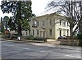
A substantial detached property, Pegasus House, number 230 London Road, is home to a veterinary practice.
Cheltenham is located at the foot of the Cotswold scarp with the small River Chelt flowing through the town. After the discovery of mineral springs in 1716 Cheltenham became a spa town and many Regency houses and other buildings were erected. The town is home to the renowned Cheltenham Festival, four days of horse jump racing culminating in the Gold Cup, held annually in March at the nearby racecourse.
Image: © Michael Dibb
Taken: 6 May 2020
0.15 miles
4
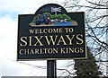
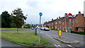
Welcome to Sixways sign, London Road
There is another of these signs on the opposite side of the road. They mark the area known as Sixways, where six roads used to meet. One of them can no longer be entered by motor traffic from the Sixways junction.
Image
Image: © P L Chadwick
Taken: 13 Mar 2010
0.15 miles
5
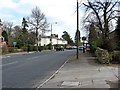
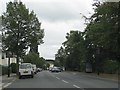
London Road near Sixways
The area is named Sixways as six roads met there.
Image
Image: © P L Chadwick
Taken: 13 Mar 2010
0.15 miles
6
The Langton, 189-191 London Road
A large busy and popular food-orientated pub, which describes itself as "country pub and eating" on its sign. The attractive building is typical of many in the Charlton Kings & Cheltenham area. The pub was closed for a while and previously was known as The Langton Horse. The horse remains in its sign.
Image
Image: © P L Chadwick
Taken: 13 Mar 2010
0.15 miles
7
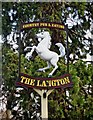
The Langton pub sign, 189-191 London Road
The pub sign of this busy establishment, formerly known as The Langton Horse.
Image
Image: © P L Chadwick
Taken: 13 Mar 2010
0.15 miles
8
Churchill Drive, Cheltenham
1950's council housing on the eastern edge of the town.
Image: © Jonathan Billinger
Taken: 27 Aug 2014
0.15 miles
10
St Edward's Preparatory School
An independent Catholic school.
Image: © Bill Boaden
Taken: 25 May 2018
0.16 miles