IMAGES TAKEN NEAR TO
London Road, CHELTENHAM, GL52 6HX
Introduction
This page details the photographs taken nearby to London Road, GL52 6HX by members of the Geograph project.
The Geograph project started in 2005 with the aim of publishing, organising and preserving representative images for every square kilometre of Great Britain, Ireland and the Isle of Man.

There are currently over 7.5m images from over14,400 individuals and you can help contribute to the project by visiting https://www.geograph.org.uk
Image Map
Images are licensed for reuse under creativecommons.org/licenses/by-sa/2.0
Notes
- Clicking on the map will re-center to the selected point.
- The higher the marker number, the further away the image location is from the centre of the postcode.
Image Listing (100 Images Found)
Images are licensed for reuse under creativecommons.org/licenses/by-sa/2.0
Image
Details
Distance
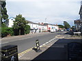
2
The London Inn, 195 London Road
A traditional inn which offers accommodation as well as food and drink. It has been here since the 1830's, serving the needs of travellers on the London Road. It still says Flowers on one of the exterior walls. Flowers Brewery closed in 1968, although apparently the beers are still brewed elsewhere.
The pub sign:- Image
Image: © P L Chadwick
Taken: 13 Mar 2010
0.01 miles
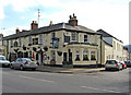
3

The London Inn (sign), 195 London Road
This traditional inn is on the corner of London Road and Oakland Street. It offers good quality reasonably priced meals, and also accommodation. It is one of the couple of survivors on the London Road.
Image
Image: © P L Chadwick
Taken: 13 Mar 2010
0.02 miles
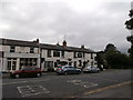
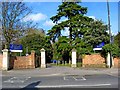
6
![Cheltenham features [16]](https://s0.geograph.org.uk/geophotos/06/53/99/6539952_68755cdb_120x120.jpg)
Cheltenham features [16]
On London Road, this driveway leads to St Edwards School and a health centre. The wall and gate piers are circa 1830 and would have been constructed after the new London Road was cut in 1825-6. Listed, grade II, with details at: https://historicengland.org.uk/listing/the-list/list-entry/1386639
Cheltenham is located at the foot of the Cotswold scarp with the small River Chelt flowing through the town. After the discovery of mineral springs in 1716 Cheltenham became a spa town and many Regency houses and other buildings were erected. The town is home to the renowned Cheltenham Festival, four days of horse jump racing culminating in the Gold Cup, held annually in March at the nearby racecourse.
Image: © Michael Dibb
Taken: 6 May 2020
0.02 miles
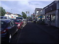
7
![Cheltenham buildings [51]](https://s1.geograph.org.uk/geophotos/06/53/99/6539953_0b162f27_120x120.jpg)
Cheltenham buildings [51]
The London Inn is circa 1834 and was constructed after the new London Road was cut in 1825-6. Some original internal features survive. Listed, grade II, with details at: https://historicengland.org.uk/listing/the-list/list-entry/1386624
Cheltenham is located at the foot of the Cotswold scarp with the small River Chelt flowing through the town. After the discovery of mineral springs in 1716 Cheltenham became a spa town and many Regency houses and other buildings were erected. The town is home to the renowned Cheltenham Festival, four days of horse jump racing culminating in the Gold Cup, held annually in March at the nearby racecourse.
Image: © Michael Dibb
Taken: 6 May 2020
0.03 miles
8
London Road entrance to St. Edward's Junior School & Kindergarten
The school and kindergarten accept children from 1 to 11 years old.
Image: © P L Chadwick
Taken: 13 Mar 2010
0.03 miles
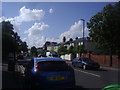
10
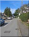
Hamilton Street, looking north
One of the residential streets off London Road. It has modern housing as well as some much older.
Image
Image: © P L Chadwick
Taken: 13 Mar 2010
0.03 miles