IMAGES TAKEN NEAR TO
Laurel Drive, CHELTENHAM, GL52 3DE
Introduction
This page details the photographs taken nearby to Laurel Drive, GL52 3DE by members of the Geograph project.
The Geograph project started in 2005 with the aim of publishing, organising and preserving representative images for every square kilometre of Great Britain, Ireland and the Isle of Man.

There are currently over 7.5m images from over14,400 individuals and you can help contribute to the project by visiting https://www.geograph.org.uk
Image Map (Loading...)


Getting Data...Please wait
Leaflet Map data © OpenStreetMap
Images are licensed for reuse under creativecommons.org/licenses/by-sa/2.0
Notes
- Clicking on the map will re-center to the selected point.
- The higher the marker number, the further away the image location is from the centre of the postcode.
Image Listing (111 Images Found)
Images are licensed for reuse under creativecommons.org/licenses/by-sa/2.0
Image
Details
Distance
2
![Prestbury houses [16]](https://s1.geograph.org.uk/geophotos/06/92/12/6921297_1d5878dc_120x120.jpg)
Prestbury houses [16]
The Lindens is set at the junction of The Burgage and New Barn Lane. Built in the late 18th or early 19th century in ashlar under a concrete tile roof. Listed, grade II, with details at: https://historicengland.org.uk/listing/the-list/list-entry/1091914
The village of Prestbury, occupied since Saxon times, is some 1½ miles northeast of the town of Cheltenham, which it once rivalled as a commercial centre. A market was established in 1249, but it declined and the historic village is now merely a suburb of the larger town. The village is home to Prestbury Park, the Cheltenham Racecourse. The village is reputed to be one of the most haunted places in Britain.
Image: © Michael Dibb
Taken: 20 May 2021
0.07 miles
3
![Prestbury houses [17]](https://s3.geograph.org.uk/geophotos/06/92/12/6921299_f8883f1b_120x120.jpg)
Prestbury houses [17]
Linden Cottage, The Burgage, is a 17th century cottage, originally detached but now joined to The Lindens Image Between stone gables and under an artificial stone slate roof, the construction is square-panelled timber-framing with painted brick noggin. The cottage was heightened and the brick wall above the first floor windows is painted to imitate timber framing. Listed, grade II, with details at: https://historicengland.org.uk/listing/the-list/list-entry/1304361
The village of Prestbury, occupied since Saxon times, is some 1½ miles northeast of the town of Cheltenham, which it once rivalled as a commercial centre. A market was established in 1249, but it declined and the historic village is now merely a suburb of the larger town. The village is home to Prestbury Park, the Cheltenham Racecourse. The village is reputed to be one of the most haunted places in Britain.
Image: © Michael Dibb
Taken: 20 May 2021
0.07 miles
5
![Prestbury houses [18]](https://s0.geograph.org.uk/geophotos/06/92/13/6921300_d136fefb_120x120.jpg)
Prestbury houses [18]
Number 5, The Burgage, is a late 17th or early 18th century cottage in a row. Timber framed but now rendered under a thatch roof. Listed, grade II, with details at: https://historicengland.org.uk/listing/the-list/list-entry/1340023
The village of Prestbury, occupied since Saxon times, is some 1½ miles northeast of the town of Cheltenham, which it once rivalled as a commercial centre. A market was established in 1249, but it declined and the historic village is now merely a suburb of the larger town. The village is home to Prestbury Park, the Cheltenham Racecourse. The village is reputed to be one of the most haunted places in Britain.
Image: © Michael Dibb
Taken: 20 May 2021
0.09 miles
6
![Prestbury houses [19]](https://s2.geograph.org.uk/geophotos/06/92/13/6921302_1b742124_120x120.jpg)
Prestbury houses [19]
Straw Cottage, number 7 The Burgage, is a 17th century timber framed cottage in a row, now rendered, under a thatch roof. Listed, grade II, with details at: https://historicengland.org.uk/listing/the-list/list-entry/1153312
Number 9 The Burgage is very similar to number 7 and is listed, grade II, with details at: https://historicengland.org.uk/listing/the-list/list-entry/1091934
The village of Prestbury, occupied since Saxon times, is some 1½ miles northeast of the town of Cheltenham, which it once rivalled as a commercial centre. A market was established in 1249, but it declined and the historic village is now merely a suburb of the larger town. The village is home to Prestbury Park, the Cheltenham Racecourse. The village is reputed to be one of the most haunted places in Britain.
Image: © Michael Dibb
Taken: 20 May 2021
0.10 miles
7
Corner of Glebe Road and Prestbury Road, Prestbury
Glebe Road is on the left.
Image: © Jaggery
Taken: 17 Mar 2019
0.11 miles
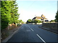
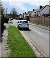
8
West along Prestbury Road, Prestbury
Double yellow lines on both sides of the B4632 Prestbury Road indicate no parking at any time.
Image: © Jaggery
Taken: 17 Mar 2019
0.11 miles
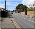
9
Glebe Road, Prestbury
Cul-de-sac on the south side of Prestbury Road.
Image: © Jaggery
Taken: 17 Mar 2019
0.13 miles
10
![Prestbury houses [15]](https://s2.geograph.org.uk/geophotos/06/92/12/6921294_71b4820a_120x120.jpg)
Prestbury houses [15]
Tatchley House is located at the junction of Tatchley Lane and Prestbury Road. Built as two 18th century parallel ranges with later rear extensions. Constructed of brick, now pebble dashed, under a slate roof. Until recently part of the house was used as a doctor's surgery. Listed, grade II, with details at: https://historicengland.org.uk/listing/the-list/list-entry/1091915
The village of Prestbury, occupied since Saxon times, is some 1½ miles northeast of the town of Cheltenham, which it once rivalled as a commercial centre. A market was established in 1249, but it declined and the historic village is now merely a suburb of the larger town. The village is home to Prestbury Park, the Cheltenham Racecourse. The village is reputed to be one of the most haunted places in Britain.
Image: © Michael Dibb
Taken: 20 May 2021
0.14 miles