
IMAGES TAKEN NEAR TO
Deep Street, CHELTENHAM, GL52 3AN
Introduction
This page details the photographs taken nearby to Deep Street, GL52 3AN by members of the Geograph project.
The Geograph project started in 2005 with the aim of publishing, organising and preserving representative images for every square kilometre of Great Britain, Ireland and the Isle of Man.

There are currently over 7.5m images from over14,400 individuals and you can help contribute to the project by visiting https://www.geograph.org.uk
Image Map
Images are licensed for reuse under creativecommons.org/licenses/by-sa/2.0
Notes
- Clicking on the map will re-center to the selected point.
- The higher the marker number, the further away the image location is from the centre of the postcode.
Image Listing (180 Images Found)
Images are licensed for reuse under creativecommons.org/licenses/by-sa/2.0
Image
Details
Distance
1
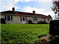
Prestbury Memorial Home Trust housing
Set back from the east side of Deep Street in Prestbury. Opened and dedicated on November 12th 1949, the building was erected as a memorial to those residents of Prestbury who gave their lives in the Second World War.
Image: © Jaggery
Taken: 17 Mar 2019
0.01 miles
2
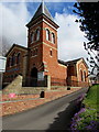
Deep Street church in Prestbury
The United Reformed Church was founded in 1866 to provide
a place for Nonconformist worship in the village.
Image: © Jaggery
Taken: 17 Mar 2019
0.01 miles
3

United Reformed Church, Prestbury
Located in Deep Street.
Image: © Pauline E
Taken: 26 Sep 2009
0.02 miles
4
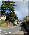
Dominant conifer above Deep Street, Prestbury
Evergreen tree viewed in March 2019.
Image: © Jaggery
Taken: 17 Mar 2019
0.02 miles
5

United Reformed Church Prestbury
Viewed across Deep Street Prestbury. The church was founded in 1866 to provide a place for Nonconformist worship in the village.
Image: © Jaggery
Taken: 17 Mar 2019
0.02 miles
6
![Prestbury buildings [5]](https://s3.geograph.org.uk/geophotos/06/92/12/6921283_440dd0f5_120x120.jpg)
Prestbury buildings [5]
This attractive church in Deep Street was built in 1866 as a Congregational chapel and became a United Reformed Church in 1972. Constructed of brick in a variety of colours under a slate roof.
The village of Prestbury, occupied since Saxon times, is some 1½ miles northeast of the town of Cheltenham, which it once rivalled as a commercial centre. A market was established in 1249, but it declined and the historic village is now merely a suburb of the larger town. The village is home to Prestbury Park, the Cheltenham Racecourse. The village is reputed to be one of the most haunted places in Britain.
Image: © Michael Dibb
Taken: 20 May 2021
0.02 miles
7

Deep Street, Prestbury
The east side of Deep Street from the corner of Blacksmiths Lane
to the United Reformed Church https://www.geograph.org.uk/photo/6089751 on the approach to High Street.
Image: © Jaggery
Taken: 17 Mar 2019
0.02 miles


10
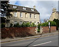
Grade II listed Three Queens, Deep Street, Prestbury
A converted former rectory, the house at 1 Deep Street has an 18th century frontage.
Part of the rear of the house may date from the 17th century.
The building was Grade II listed in 1960.
Image: © Jaggery
Taken: 17 Mar 2019
0.02 miles