IMAGES TAKEN NEAR TO
Peghouse Rise, STROUD, GL5 1UR
Introduction
This page details the photographs taken nearby to Peghouse Rise, GL5 1UR by members of the Geograph project.
The Geograph project started in 2005 with the aim of publishing, organising and preserving representative images for every square kilometre of Great Britain, Ireland and the Isle of Man.

There are currently over 7.5m images from over14,400 individuals and you can help contribute to the project by visiting https://www.geograph.org.uk
Image Map (Loading...)


Getting Data...Please wait
Leaflet Map data © OpenStreetMap
Images are licensed for reuse under creativecommons.org/licenses/by-sa/2.0
Notes
- Clicking on the map will re-center to the selected point.
- The higher the marker number, the further away the image location is from the centre of the postcode.
Image Listing (8 Images Found)
Images are licensed for reuse under creativecommons.org/licenses/by-sa/2.0
Image
Details
Distance
1
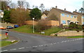
Corner of Slad Road and Peghouse Rise, Stroud
Viewed across Slad Road. The street name sign shows Peghouse Rise leading to Shepherds Croft.
Image: © Jaggery
Taken: 8 Jan 2012
0.08 miles
2
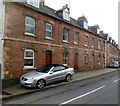
Slad Road houses, Stroud
The name Woodland Terrace is inscribed in stone above a doorway, but there was no modern street sign showing this name. The address of the houses is Slad Road.
Image: © Jaggery
Taken: 8 Jan 2012
0.09 miles
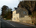
3
Gloucester Street Forge Ltd, Stroud
Despite its name, located at 140 Slad Road in The Old Forge.
The name sign shows that the firm's business is ornamental ironwork and steel fabrication.
Image: © Jaggery
Taken: 8 Jan 2012
0.12 miles
4
Slade Brook and Captain Barton Close, Stroud
Viewed across Slad Road. Houses in Slade Brook to the right, Captain Barton Close to the left.
I wonder if the spelling Slade in the street name (as shown on the street name sign and on maps)
was chosen to distinguish the street from the nearby brook, Slad Brook.
Image: © Jaggery
Taken: 8 Jan 2012
0.13 miles
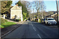
5
The Lodge, Slad Road, Stroud
Confusingly, the name on the wall on the far side of the house is Slad Valley House,
which is set back 50 metres at the end of a driveway from Slad Road.
The house in view, now a private residence, was built as the lodge for Slad Valley House.
Image: © Jaggery
Taken: 8 Jan 2012
0.13 miles
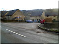
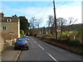
6
B4070 Slad Road
Towards Slad from Stroud. The gates to Slad Valley House are on the left.
Image: © Robin Webster
Taken: 9 Jan 2022
0.14 miles
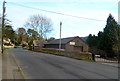
7
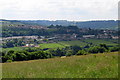
Looking towards Painswick
A view from Folley Lane looking south towards the outskirts of Painswick.
Image: © Sharon Loxton
Taken: 6 Jun 2008
0.14 miles
8
Bends for 2 miles ahead, Slad Road, Stroud
The road ahead to Slad is through the valley of Slad Brook.
Image: © Jaggery
Taken: 8 Jan 2012
0.18 miles