IMAGES TAKEN NEAR TO
Beeches Green, STROUD, GL5 1SA
Introduction
This page details the photographs taken nearby to Beeches Green, GL5 1SA by members of the Geograph project.
The Geograph project started in 2005 with the aim of publishing, organising and preserving representative images for every square kilometre of Great Britain, Ireland and the Isle of Man.

There are currently over 7.5m images from over14,400 individuals and you can help contribute to the project by visiting https://www.geograph.org.uk
Image Map
Images are licensed for reuse under creativecommons.org/licenses/by-sa/2.0
Notes
- Clicking on the map will re-center to the selected point.
- The higher the marker number, the further away the image location is from the centre of the postcode.
Image Listing (407 Images Found)
Images are licensed for reuse under creativecommons.org/licenses/by-sa/2.0
Image
Details
Distance
1
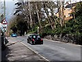
Skid risk for 550 yards ahead, Beeches Green, Stroud
The triangular warning sign is alongside the A46.
Image: © Jaggery
Taken: 23 Mar 2014
0.07 miles
2
Entrance to Beeches Green Health Centre, Stroud
From the A46 Beeches Green.
Image: © Jaggery
Taken: 23 Mar 2014
0.07 miles
3
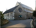
Church of the Immaculate Conception, Stroud
Roman Catholic church viewed from the A46 Beeches Green.
Image: © Jaggery
Taken: 15 Jan 2012
0.08 miles
5
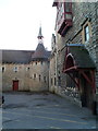
Bell tower, The Old Convent, Stroud
Located on the south side of the Church of the Immaculate Conception. http://www.geograph.org.uk/photo/3546288
Image: © Jaggery
Taken: 15 Jan 2012
0.09 miles
6
Beeches Green Health Centre, Stroud
Located on the south side of the A46 Beeches Green in the Beeches Green area of Stroud.
Image: © Jaggery
Taken: 15 Jan 2012
0.10 miles
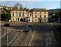
7
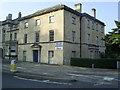
The Old Police Station
A fine old stone building, now (2014) empty and looking for a buyer.
Image: © Graham Hale
Taken: 19 Jul 2014
0.11 miles
8
Old Police Station offices to let in Stroud
In late December 2014, an Office Suites To Let board is on the wall
of the former police station. Stroud's current police station is here. http://www.geograph.org.uk/photo/4298751
Image: © Jaggery
Taken: 28 Dec 2014
0.11 miles
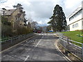
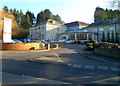
9

Merrywalks footbridge, Stroud
The footbridge is over the A46 Merrywalks at the NE edge of Merrywalks Shopping Centre.
Image: © Jaggery
Taken: 8 Jan 2012
0.11 miles
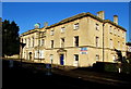
10
Grade II listed former Stroud police station and court
Viewed from this http://www.geograph.org.uk/photo/3303092 footbridge. Now in use as offices (Willow Court), this was formerly Stroud police station (on the right) and a Petty Sessional court on the left. Grade II listed in May 1951.
Image: © Jaggery
Taken: 8 Jan 2012
0.11 miles