IMAGES TAKEN NEAR TO
Slad Road, STROUD, GL5 1QZ
Introduction
This page details the photographs taken nearby to Slad Road, GL5 1QZ by members of the Geograph project.
The Geograph project started in 2005 with the aim of publishing, organising and preserving representative images for every square kilometre of Great Britain, Ireland and the Isle of Man.

There are currently over 7.5m images from over14,400 individuals and you can help contribute to the project by visiting https://www.geograph.org.uk
Image Map
Images are licensed for reuse under creativecommons.org/licenses/by-sa/2.0
Notes
- Clicking on the map will re-center to the selected point.
- The higher the marker number, the further away the image location is from the centre of the postcode.
Image Listing (32 Images Found)
Images are licensed for reuse under creativecommons.org/licenses/by-sa/2.0
Image
Details
Distance
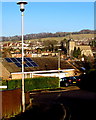
1
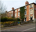
Corner of Slad Road and Sycamore Drive, Stroud
Sycamore Drive passes houses in Slad Road.
Image: © Jaggery
Taken: 8 Jan 2012
0.01 miles
2
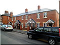
Recently-built housing, Slad Road, Stroud
The year 2010 in inscribed on the wall.
Image: © Jaggery
Taken: 8 Jan 2012
0.02 miles
3
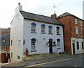
A white and blue house, Slad Road, Stroud
The house is near the junction with Springfield Road and Lansdown, close to The Fountain Inn. http://www.geograph.org.uk/photo/3304511
Image: © Jaggery
Taken: 8 Jan 2012
0.03 miles
4
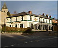
The Fountain Inn, Stroud
Pub on the corner of Springfield Road and Slad Road.
Image: © Jaggery
Taken: 8 Jan 2012
0.04 miles
5
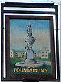
The Fountain Inn name sign, Stroud
Located on a post outside this pub. http://www.geograph.org.uk/photo/3304511
Image: © Jaggery
Taken: 8 Jan 2012
0.05 miles
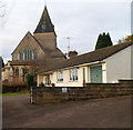
6
View from Belle Vue Road, Stroud
The church is All Saints. http://www.geograph.org.uk/photo/3305064
Image: © Jaggery
Taken: 28 Dec 2014
0.05 miles
7
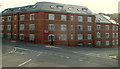
Little Mill Court, Stroud
Recently-built flats on the corner of Slad Road and Lansdown,
occupying part of the site of the former Slad (cloth) Mill.
Image: © Jaggery
Taken: 8 Jan 2012
0.06 miles
8
East side of All Saints Church, Stroud
Viewed from Sycamore Drive.
Image: © Jaggery
Taken: 8 Jan 2012
0.06 miles
9
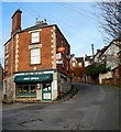
Uplands Post Office, Stroud
Located in Springfield House, at the junction of Uplands Road and Springfield Road (on the right), Uplands Post Office is a rare example of a post office reopening after being closed down.
In 2008, this post office was one of seven in the Stroud area to be closed, as part of the cost-cutting exercise which closed 2,500 post offices in the UK.
After a vigorous local campaign, and financial support from Stroud town council, the post office reopened a few months after closure. A key factor was a High Court ruling that a local 74-year-old disabled person would be discriminated against because of the difficulties she would face getting to another post office.
Image: © Jaggery
Taken: 8 Jan 2012
0.07 miles
10
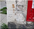
Ordnance Survey Cut Mark
This OS cut mark can be found on the Post Office. It marks a point 65.017m above mean sea level.
Image: © Adrian Dust
Taken: 13 Sep 2016
0.07 miles