IMAGES TAKEN NEAR TO
Little Mill Court, STROUD, GL5 1DJ
Introduction
This page details the photographs taken nearby to Little Mill Court, GL5 1DJ by members of the Geograph project.
The Geograph project started in 2005 with the aim of publishing, organising and preserving representative images for every square kilometre of Great Britain, Ireland and the Isle of Man.

There are currently over 7.5m images from over14,400 individuals and you can help contribute to the project by visiting https://www.geograph.org.uk
Image Map (Loading...)


Getting Data...Please wait
Leaflet Map data © OpenStreetMap
Images are licensed for reuse under creativecommons.org/licenses/by-sa/2.0
Notes
- Clicking on the map will re-center to the selected point.
- The higher the marker number, the further away the image location is from the centre of the postcode.
Image Listing (46 Images Found)
Images are licensed for reuse under creativecommons.org/licenses/by-sa/2.0
Image
Details
Distance
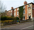
1
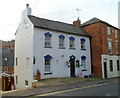
A white and blue house, Slad Road, Stroud
The house is near the junction with Springfield Road and Lansdown, close to The Fountain Inn. http://www.geograph.org.uk/photo/3304511
Image: © Jaggery
Taken: 8 Jan 2012
0.02 miles
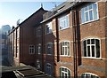
2
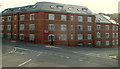
Little Mill Court, Stroud
Recently-built flats on the corner of Slad Road and Lansdown,
occupying part of the site of the former Slad (cloth) Mill.
Image: © Jaggery
Taken: 8 Jan 2012
0.02 miles
3
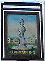
The Fountain Inn name sign, Stroud
Located on a post outside this pub. http://www.geograph.org.uk/photo/3304511
Image: © Jaggery
Taken: 8 Jan 2012
0.03 miles
4
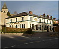
The Fountain Inn, Stroud
Pub on the corner of Springfield Road and Slad Road.
Image: © Jaggery
Taken: 8 Jan 2012
0.03 miles
5
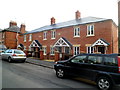
Recently-built housing, Slad Road, Stroud
The year 2010 in inscribed on the wall.
Image: © Jaggery
Taken: 8 Jan 2012
0.04 miles
6
Slad Mill
This was a cloth mill, built in 1890 by the Slad Brook to the northeast of Stroud. It is now luxury apartments.
Image: © Derek Harper
Taken: 19 Oct 2007
0.04 miles
7
Corner of Slad Road and Sycamore Drive, Stroud
Sycamore Drive passes houses in Slad Road.
Image: © Jaggery
Taken: 8 Jan 2012
0.05 miles
8
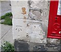
Ordnance Survey Cut Mark
This OS cut mark can be found on the Post Office. It marks a point 65.017m above mean sea level.
Image: © Adrian Dust
Taken: 13 Sep 2016
0.06 miles
9
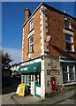
Uplands Sub Post Office, Stroud
Image: © Derek Harper
Taken: 19 Oct 2007
0.06 miles
10
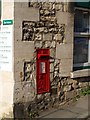
George V postbox, Uplands
A wall-mounted box bearing the distinctive little crown. One of the quoins of Image bears a benchmark - 65.02 metres above sea level, according to the map.
Image: © Derek Harper
Taken: 19 Oct 2007
0.06 miles