IMAGES TAKEN NEAR TO
Tewkesbury Road, CHELTENHAM, GL51 9SY
Introduction
This page details the photographs taken nearby to Tewkesbury Road, GL51 9SY by members of the Geograph project.
The Geograph project started in 2005 with the aim of publishing, organising and preserving representative images for every square kilometre of Great Britain, Ireland and the Isle of Man.

There are currently over 7.5m images from over14,400 individuals and you can help contribute to the project by visiting https://www.geograph.org.uk
Image Map (Loading...)


Getting Data...Please wait
Leaflet Map data © OpenStreetMap
Images are licensed for reuse under creativecommons.org/licenses/by-sa/2.0
Notes
- Clicking on the map will re-center to the selected point.
- The higher the marker number, the further away the image location is from the centre of the postcode.
Image Listing (14 Images Found)
Images are licensed for reuse under creativecommons.org/licenses/by-sa/2.0
Image
Details
Distance
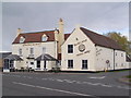
2
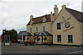
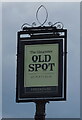
The Gloucester Old Spot
The Gloucester Old Spot stands beside the A4019 at Piff's Elm.
Image: © Philip Halling
Taken: 27 Aug 2005
0.01 miles
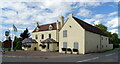
3
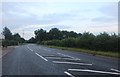
The A4019, Piff's Elm
It belonged to the Piff family, logical. https://en.wikipedia.org/wiki/Piff%27s_Elm
Image: © David Howard
Taken: 3 Aug 2019
0.01 miles
5
Bus stop on A4019, south of Knightsbridge
Image: © David Smith
Taken: 15 Aug 2022
0.03 miles

7
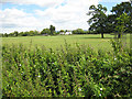
Farmland north of Boddington
Part of Boddington Estates. The buildings are alongside the A4019.
Image: © Pauline E
Taken: 12 Jul 2008
0.08 miles
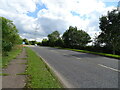
8
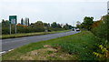
A4019 towards Cheltenham
A link between the A38 and the M5.
Image: © Jonathan Billinger
Taken: 24 Oct 2016
0.08 miles