IMAGES TAKEN NEAR TO
Tewkesbury Road, CHELTENHAM, GL51 9SX
Introduction
This page details the photographs taken nearby to Tewkesbury Road, GL51 9SX by members of the Geograph project.
The Geograph project started in 2005 with the aim of publishing, organising and preserving representative images for every square kilometre of Great Britain, Ireland and the Isle of Man.

There are currently over 7.5m images from over14,400 individuals and you can help contribute to the project by visiting https://www.geograph.org.uk
Image Map (10 Images)


Getting Data...Please wait
Leaflet Map data © OpenStreetMap
Images are licensed for reuse under creativecommons.org/licenses/by-sa/2.0
Notes
- Clicking on the map will re-center to the selected point.
- The higher the marker number, the further away the image location is from the centre of the postcode.
Image Listing (10 Images Found)
Images are licensed for reuse under creativecommons.org/licenses/by-sa/2.0
Image
Details
Distance
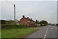
1
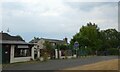
Workshop for ironwork, Uckington
This is by the side of the old road, now bypassed with a straighter A-road
Image: © David Smith
Taken: 15 Aug 2022
0.02 miles
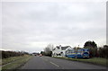
5
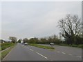
Lay-by by A4019 east of M5 junction 10
A large lay-by, convenient for car-sharing for users of the M5 northbound
Image: © David Smith
Taken: 6 May 2016
0.09 miles

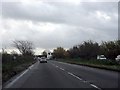
7
End of dual carriageway, eastbound A4019
Image: © Peter Whatley
Taken: 22 Nov 2012
0.24 miles
8
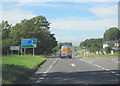
A4019 Uckington Approaching M5 Motorway Junction
Image: © Roy Hughes
Taken: 8 Sep 2012
0.24 miles
9
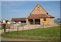
Barn conversion taking place
At Pigeon House Farm.
Image: © Pauline E
Taken: 26 Jul 2008
0.25 miles
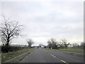
10
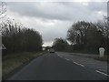
A4019 in Uckington
There is a left turn lane off the main road for the turn to Elmstone Hardwicke
Image: © David Smith
Taken: 6 May 2016
0.25 miles