IMAGES TAKEN NEAR TO
Tewkesbury Road, CHELTENHAM, GL51 9SW
Introduction
This page details the photographs taken nearby to Tewkesbury Road, GL51 9SW by members of the Geograph project.
The Geograph project started in 2005 with the aim of publishing, organising and preserving representative images for every square kilometre of Great Britain, Ireland and the Isle of Man.

There are currently over 7.5m images from over14,400 individuals and you can help contribute to the project by visiting https://www.geograph.org.uk
Image Map
Images are licensed for reuse under creativecommons.org/licenses/by-sa/2.0
Notes
- Clicking on the map will re-center to the selected point.
- The higher the marker number, the further away the image location is from the centre of the postcode.
Image Listing (28 Images Found)
Images are licensed for reuse under creativecommons.org/licenses/by-sa/2.0
Image
Details
Distance
1
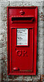
George V postbox on Tewkesbury Road, Uckington
Postbox No. GL51 118.
Image: © JThomas
Taken: 9 Aug 2021
0.03 miles
3
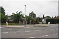
Bus stop and phone box in Uckington
The view from the bus stop on the opposite side of the A4019.
Image: © Bill Boaden
Taken: 4 Jun 2018
0.05 miles
4
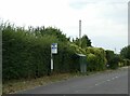
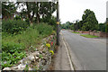
Overgrown footpath and hedge by bus shelter, Uckington
Image: © David Smith
Taken: 15 Aug 2022
0.06 miles
5
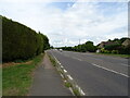
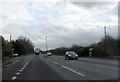
Tewkesbury Road (A4019), Uckington
Towards Cheltenham.
Image: © JThomas
Taken: 9 Aug 2021
0.06 miles
8
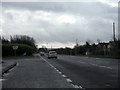
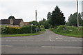
The road from Elmstone Hardwicke
A lot of the houses in Uckington are relatively new.
Image: © Bill Boaden
Taken: 4 Jun 2018
0.09 miles
9
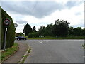
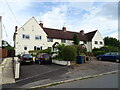
The Green, Uckington
Junction with Tewkesbury Road (A4019).
Image: © JThomas
Taken: 9 Aug 2021
0.10 miles
10
Moat Lane, Uckington
As the name suggests, it leads to the moat.
Image: © Bill Boaden
Taken: 4 Jun 2018
0.10 miles