IMAGES TAKEN NEAR TO
Manor Road, CHELTENHAM, GL51 9NR
Introduction
This page details the photographs taken nearby to Manor Road, GL51 9NR by members of the Geograph project.
The Geograph project started in 2005 with the aim of publishing, organising and preserving representative images for every square kilometre of Great Britain, Ireland and the Isle of Man.

There are currently over 7.5m images from over14,400 individuals and you can help contribute to the project by visiting https://www.geograph.org.uk
Image Map
Images are licensed for reuse under creativecommons.org/licenses/by-sa/2.0
Notes
- Clicking on the map will re-center to the selected point.
- The higher the marker number, the further away the image location is from the centre of the postcode.
Image Listing (27 Images Found)
Images are licensed for reuse under creativecommons.org/licenses/by-sa/2.0
Image
Details
Distance
1

Cotswold Bowl Ten Pin Bowling Lanes
Cotswold Bowl is in the heart of the Kingsditch industrial estate.
Image: © Stephen Bowden
Taken: 23 Apr 2005
0.16 miles
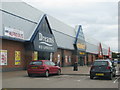
2
Comet, Unit 8 Gallagher Retail Park, Tewkesbury Road, Cheltenham
For many years Comet along with Currys/PC World have been the two leading electrical retailers in the UK. Unfortunately the economic recession coupled with the rise of on-line retailers has hit Comet badly. Coupled with various changes of ownership in recent years, with a bit of asset stripping en route, it was no surprise when early November 2012, the company suddenly went into administration. The administrators have put most of the stock on sale with varying discounts, with posters in the windows announcing that everything must go. Unless a buyer materialises, it seems that most or all the stores might be closed in a matter of days. The biggest losers in this situation are always the staff and the creditors. In this branch, which seemed to still be relatively well stocked, the staff were today having to cope with the effects of the computer system having crashed.
Image: © P L Chadwick
Taken: 20 Nov 2012
0.20 miles
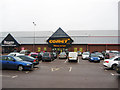
3
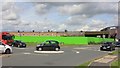
Gallagher Retail Park
The out of town Gallagher Retail Park on Tewkesbury Road in Cheltenham.
Image: © Philip Halling
Taken: 27 Sep 2019
0.21 miles
5
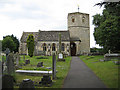
Church of St Lawrence, Swindon Village
The tower is dated around 1100 AD and is unusual in that it is six-sided, one of only two in the county (the other is at Osleworth, 20 miles to the south). The church was largely rebuilt during the Victorian era.
Image: © Pauline E
Taken: 12 Jul 2008
0.22 miles
6
Vibixa Factory 1
Vibixa was a well known factory that used to make packaging for products like Weetabix. For many years a large portion of the factory, was hidden behind a huge hedge. It was a sad day for the employees, when the factory closed. The factory was sold to developers, and is now being demolished to make way for retail units
Image: © Helen Iwanczuk
Taken: 21 Aug 2019
0.22 miles
7
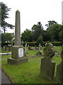
War memorial, Swindon Village
In the churchyard of St Lawrence.
Image: © Pauline E
Taken: 12 Jul 2008
0.22 miles
8
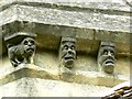
Grotesques, St Lawrence's Church, Swindon Village, Cheltenham
Although the church has its origins in the 12th century, these characters probably date only to the mid 19th century when the church was largely rebuilt. They are to be found on the south-eastern section of the unusual hexagonal tower.
Image: © Brian Robert Marshall
Taken: 1 Aug 2014
0.22 miles
9

Edge of town shopping centre
The usual stores in the usual places.
Image: © Jonathan Billinger
Taken: 16 Jan 2016
0.22 miles
10
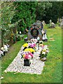
Family graves, St Lawrence's Church, Swindon Village, Cheltenham
The ornate Willett family graves are in sharp contrast to the other, rather grey and rather older ones within the churchyard.
Image: © Brian Robert Marshall
Taken: 1 Aug 2014
0.22 miles