IMAGES TAKEN NEAR TO
Baker Street, CHELTENHAM, GL51 9HG
Introduction
This page details the photographs taken nearby to Baker Street, GL51 9HG by members of the Geograph project.
The Geograph project started in 2005 with the aim of publishing, organising and preserving representative images for every square kilometre of Great Britain, Ireland and the Isle of Man.

There are currently over 7.5m images from over14,400 individuals and you can help contribute to the project by visiting https://www.geograph.org.uk
Image Map
Images are licensed for reuse under creativecommons.org/licenses/by-sa/2.0
Notes
- Clicking on the map will re-center to the selected point.
- The higher the marker number, the further away the image location is from the centre of the postcode.
Image Listing (93 Images Found)
Images are licensed for reuse under creativecommons.org/licenses/by-sa/2.0
Image
Details
Distance
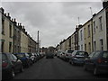
3

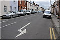
Northern end of Townsend Street, Cheltenham
Image: © Peter Whatley
Taken: 22 Nov 2012
0.02 miles
4
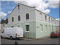
Gas Green Baptist Church
Russell Street/ Baker Street, Cheltenham. Built circa 1836. The building has been used by various denominations including Independents, Primitive Methodists and now by the Baptists. Originally the church was sited on the southern side of Tewkesbury Road but was demolished in 1836 when the gas works was extended.
Image: © Pauline E
Taken: 4 Jul 2008
0.03 miles
5
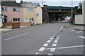
Swindon Road railwaybridge
This bridge carried the Cheltenham to Honeybourne line over Swindon Road.
Image: © Terry Jacombs
Taken: 28 Mar 2012
0.04 miles
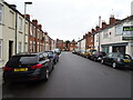
6
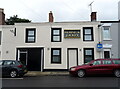
The Horse & Jockey, Cheltenham
On Townsend Street.
Image: © JThomas
Taken: 13 Aug 2021
0.04 miles
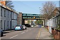
7
Swindon Road, Cheltenham
The railway bridge used to carry the Cheltenham to Stratford-upon-Avon line which closed in the 1970s.
Image: © Philip Halling
Taken: 13 Aug 2011
0.04 miles
8
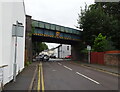
Disused railway bridge over Swindon Road, Cheltenham
Now used by National Cycle Route 41.
Image: © JThomas
Taken: 13 Aug 2021
0.04 miles
10
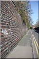
Railway retaining wall, Carlton Place
The Cheltenham to Honeybourne railway line used to run on the embankment behind this retaining wall.
Image: © Terry Jacombs
Taken: 28 Mar 2012
0.05 miles